|
THE SOLAR SYSTEM
|
The past 25 years have been an exciting time to be an amateur astronomer, especially one interested in our own backyard, the Solar System. Currently, there are so many new and exciting discoveries - from the Sun to the Kuiper Belt - that it’s impossible to cover everything in a 40 minute talk, so I’ve chosen to focus on a selection of current controversies. That’s to say controversies that appeal to me personally as a geologist of more than 40 years professional experience. A geological perspective – plus time constraints - means I’ll focus here on the rocky planets, and then jump to Pluto.
What exactly do I mean by “controversy”? In contrast to a “debate” where protagonists disagree but acknowledge the other side of the argument, I take “controversy” to imply that protagonists are either ignoring the obvious, or ignoring the existence and/or the validity of alternative evidence and interpretations. Examples of debates related to the Solar System would include: expanding moons, be they made of ice or rock; geologically recent thermal contraction of Mercury and of our own Moon; the resurfacing of Venus; early Mars climate; the origin of our Moon; the potential for chaotic orbital behaviour in our Solar System, even after 4.5 Ga; and the very existence of the Late Heavy Bombardment, with all that implies for dating events across the Solar System as a whole.
Before getting to controversies, let’s not forget that there have been many key advances in our understanding of how the planetary component of our Solar System formed and evolved. Let’s look at just two: starting with our understanding of how planets are created from gas and dust in a primordial solar nebula (see here and here).
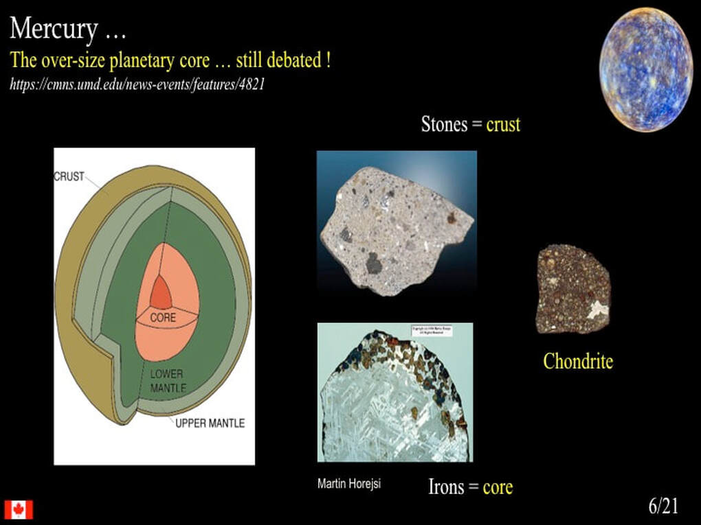
Decades ago, the picture was simple: accretion. Accretion to form chondrules that go on to accrete to form planetoids, that then accrete to form differentiated planets (core + mantle + crust). However, we now know it’s not that easy.
First, it turns out that chondrules are more complex than initially thought. Many contain older crystals - some quite large - that required time to grow prior to their incorporation within Chondrules, and the chondrules themselves are commonly stuck together with glass that represents quenched or chilled melt that formed almost instantaneously. These contradictory observations require that chondrules and planetoids were actively forming at the same time, probably during the first 5 Ma of Solar System history. Second, we now know that there’s a tendency for elastic rebound and fragmentation to dominate over accretion when colliding asteroidal objects get to about 1 metre in size, so there’s a series of computer models under active development to get accretion to pass through this 1 metre size barrier.
Let’s now jump to the scale of the Solar System itself. Perhaps the most significant recent advance at the scale of the Solar System is the formulation of the « Grand Tack » and « Nice » models, inspired by the detection of so-called “hot Jupiters” in exo-planetary systems. According to the « Grand Tack » model, Jupiter migrated toward the inner Solar System, followed by Saturn, at some time during the first 10-100 Ma of the Solar System’s existence. Saturn and Jupiter then found themselves in a specific mutual resonance that resulted in a reversal of their migration.
Things then get a little fuzzy for the next ~600 Ma, but eventually Jupiter and Saturn attained a new, stable resonance that put paid to their inward/outward migrations. Meanwhile, their gravitational interaction with Neptune and Uranus pushed the two ice giants outward toward the Kuiper Belt, from which all hell let loose at 4.0-3.8 Ga - technically referred to as the Late Heavy Bombardment. This part of the story - the « Nice » model - potentially explains how the Late Heavy Bombardment started and ended, why Mars is so much smaller than the other rocky planets, and the compositional zonation of the Asteroid Belt. Most importantly, it suggests that the early history of the Solar System was nothing like the stable, clock-work mechanism that we learned about in school.
But I want to talk about matters that – in my opinion – are more controversial than these, relating to Mercury, Venus, Mars and Pluto
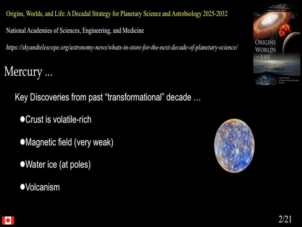
Let’s start with Mercury : Mercury was recently mapped and studied in some detail by NASA’s MESSENGER probe. As the spelled-out acronym clearly states, a major theme of the MESSENGER mission was Mercury’s surface geochemistry. Why ?
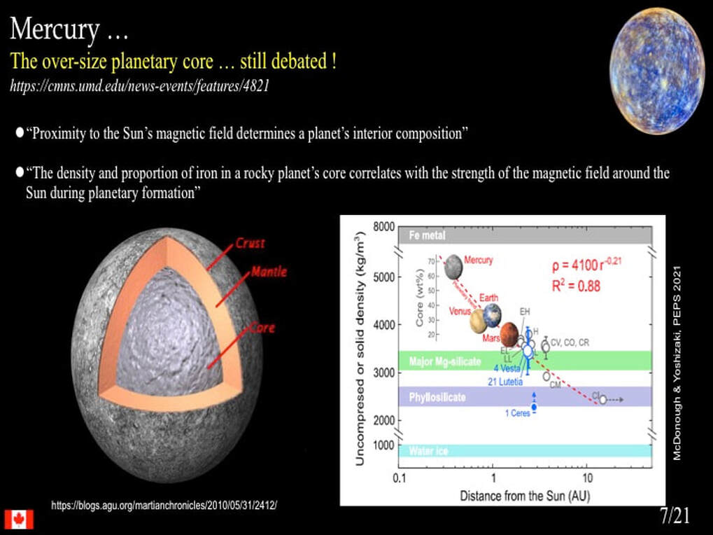
Because Mercury is a problem planet : it’s a problem because the standard accretionary model of Solar System formation does not explain its anomalously huge Fe-Ni core. Prior to the MESSENGER mission, there were several theories on the table to account for the disproportionate volume of Mercury ‘s core, several of which invoked planetary collisions or the early Sun to remove the outer part of a standard planetary mantle, which implies removal of the early crust too! Surely, the acid test of these hypotheses would be the presence or absence of Mercury’s primeval crust.
MESSENGER quickly revealed that the pre-mission idea that Mercury’s crust was primeval and anorthositic - similar to that of our Moon - was wrong. Instead, there is a time sequence of basaltic volcanism covering the first quarter of Mercury’s history. Keeping a close watch on this most interesting result, I was intrigued that no-one was offering an explicit interpretation of what this means in terms of Mercury’s planetary development. Surely, this was one of the prime justifications of the MESSENGER mission. Since ~ 2015 several well reasoned research papers have proposed an intriguing interpretation of the abundant carbon that had been found all over Mercury.
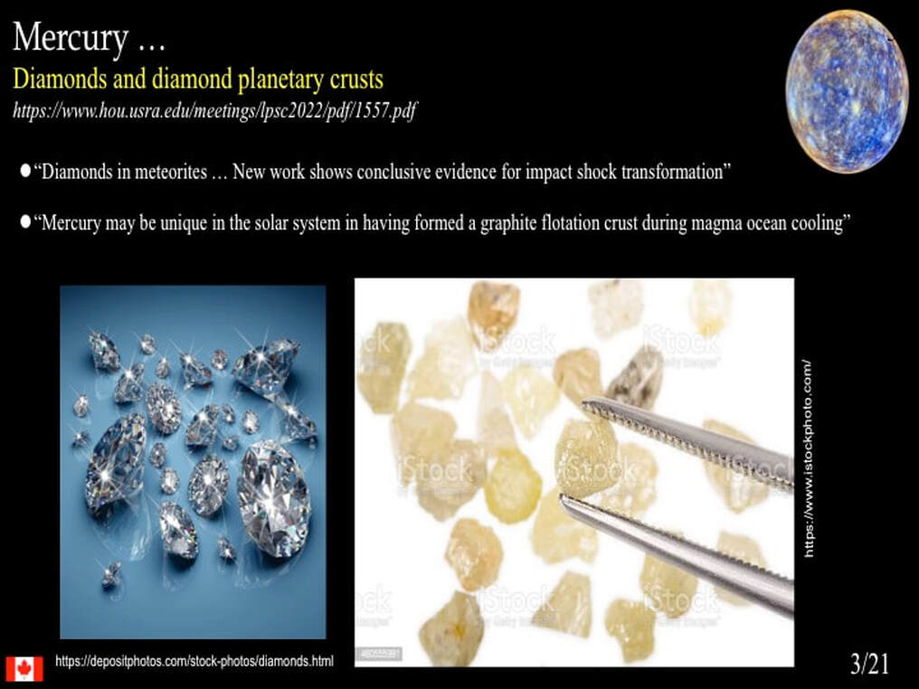
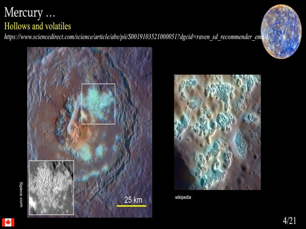
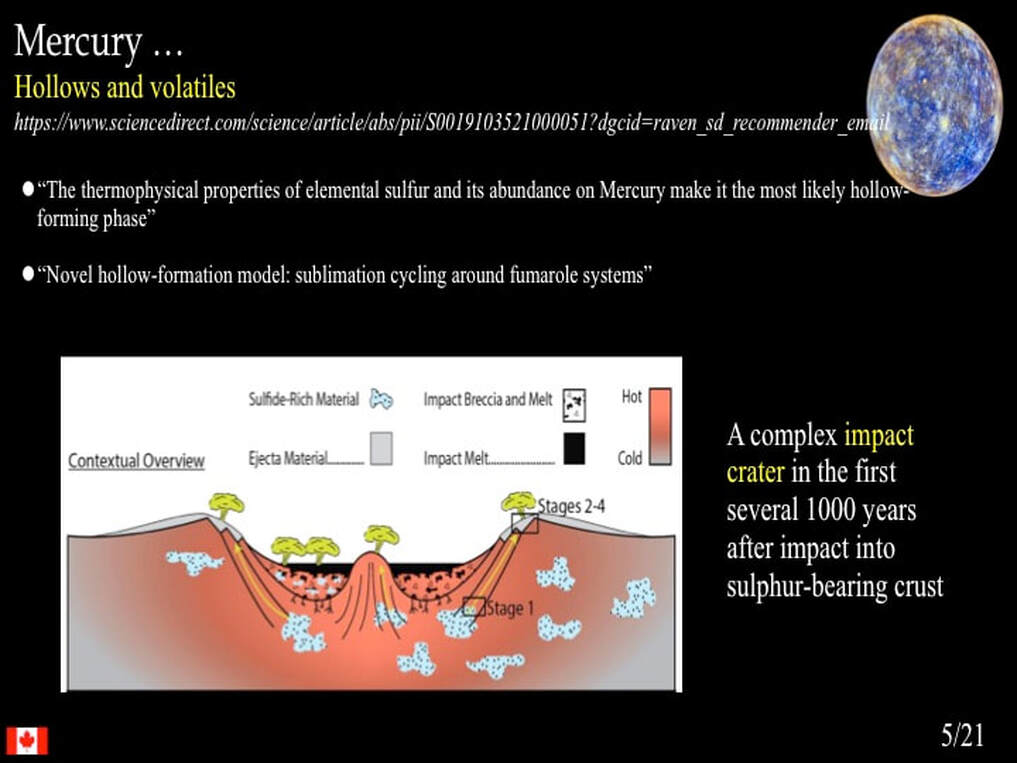
In this image you can also see a detail of the dark carbon ejecta excavated and thrown out of the impact cavity at Basho crater; just one of many, many such examples. The authors of these papers interpret the carbon as an original floating scum that accumulated on the top of a global magma ocean that itself formed from the heat of Mercury’s accretion and perhaps the heat of the formation of Mercury’s core, hence it is part (potentially the whole) of the planet’s primeval crust – now mixed with the secondary volcanic crust as it developed and was broken up by impacts. Much was made of the carbon as an explanation for Mercury’s unusually dark colour, but to my knowledge nothing has been explicitly stated regarding the elimination of all hypotheses for the planet’s large core that appeal to the removal of the outer mantle and, therefore, of the primitive crust. Why ? I really don’t know … but the highly controversial hypotheses it leaves on the table include the very prickly idea that somehow the solar nebula was enriched in Fe and Ni ONLY where Mercury formed – for reasons unknown - or that the oxidation state of the solar nebula was somehow geared to be reducing and thereby favour anomalous precipitation of Fe and Ni only adjacent to the Sun. Whatever, Mercury calls for a reassessment of at least part of the Solar System accretionary model … and that’s potentially controversial!
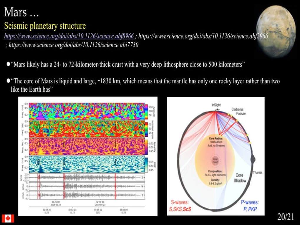
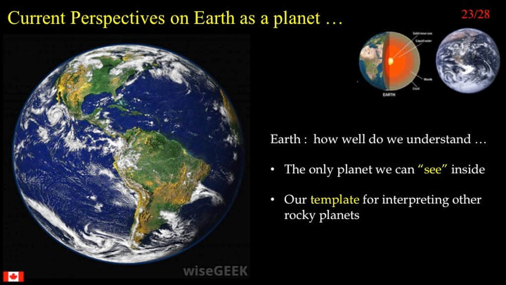
You might be surprised to see the Earth figure in this part of the presentation. After all, with our geophysical capabilities we can « see » inside the planet in a way we cannot hope to do elsewhere … yet! Well, there is indeed a controversy regarding the physical behaviour of the Earth’s mantle.
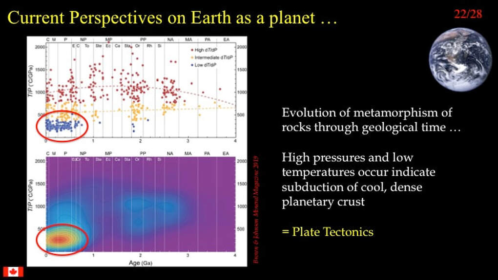
The issue concerns the nature of convection in the planetary mantle. According to the standard or consensus model, the whole mantle convects, driven from below by the heat of the planet’s core. Hot mantle material rises buoyantly through the overlying cooler mantle to form hot spots or plumes that can raise an overlying continent, break it and initiate the rifting component of plate tectonics. The subducting component of plate tectonics involves cooler crust and uppermost mantle material that sink right down to the mantle-core boundary.
However, this model has been challenged by a well respected geoscientist of international standing. The late Don Anderson was a professor at Cal Tech.,He made the important point that the consensus model for mantle convection is principally thermally-based and ignores the well established effects of pressure on material properties such as coefficients of expansion and viscosity. The consequence of these effects is that the lower mantle is too stiff and insufficiently buoyant to rise in a convective mode. So Anderson proposed that the mantle is physically partitioned into a less mobile, sluggish lower mantle, and a more mobile upper mantle that responds to the motions of Plate Tectonics in the overlying crust and lithosphere. Notice that in this image, Anderson presented the consensus model of mantle behaviour – the Plume Model – on the left and his revised model on the right. Mantle plumes, driven from below by the heat of the Earth’s core are only predicted in the consensus model, whose validity he challenges. In a nutshell, Anderson challenges the very existence of mantle plumes as a planetary process. So, why is this important ?
Venus! The consensus model to explain the surface features of Venus is predicated on a direct parallel with the consensus model for the Earth’s mantle.
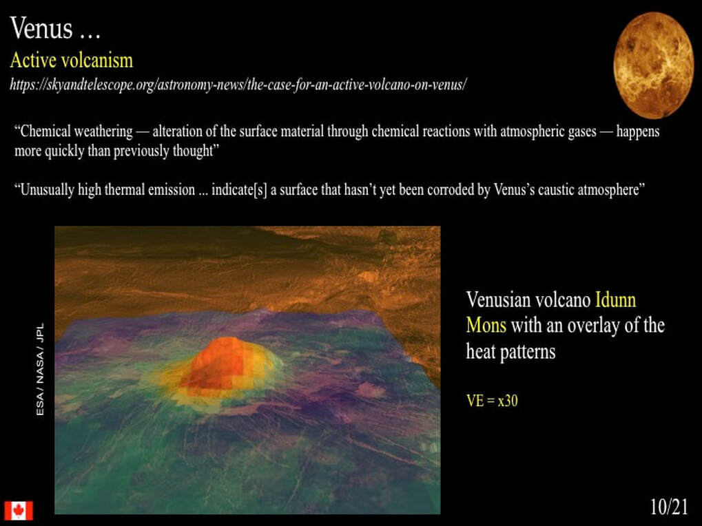
According to consensus, the major (100-1000 km) circular features on the venusian surface formed over the tops of rising, viscous mantle plumes. These features are known on Venus as « Coronae » and – according to planetary scientists – are unique to Venus.
Here is a classic example where you can see a large circular area surrounded by a raised rim with a steep inward facing slope and a gentle outward facing slope. The inset is a simplified model of the corona forming over the top of a rising, viscous mantle plume. The bright radial features could be fractures, or they could be magmatic dykes, or both! But what if mantle plumes don’t exist?
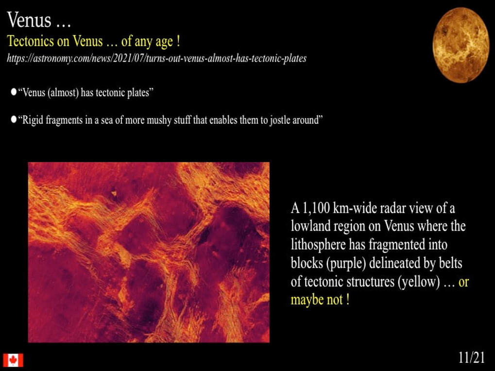
Another geoscientist of international standing – one of the founding fathers of the modern terrestrial Plate Tectonic paradigm – has joined Anderson in asking this very question. Warren Hamilton – a senior scientist at the USGS – has taken a careful look at the radar images of the venusian surface, including this one. The consensus interpretation is that this is a Corona, but according to Hamilton, we are looking here at a large impact crater, with a central peak on its floor and a raised rim with steep inward and gentle outward slopes. Just below the inner wall of the rim is a series of stepped terraces formed by collapse of the initial impact cavity. You have to admit, he has a point.
This purported Corona structure on the other hand is not so easy to write off as an impact feature
However, Hamilton make a very telling observation regarding features generally accepted as Coronae. Where they cut each other in time sequence, they do so in cookie-cutter fashion, without any distortion of the older structures. As he points out, this is difficult to explain in a slowly evolving viscous plume-driven model, but is precisely what you’d expect in an instantaneous impact model. Has Hamilton convinced the scientific community that he is right and they are wrong? No: remember, this is a controversy! For example, if these are impact features, where are the ejecta deposits? My take home message here is that Hamilton has not yet proven his point, but both he and Anderson are generally ignored by the scientific community that works on mantle plumes on Earth, and the surface features of Venus. This is poor scientific practice! If people of the stature of Anderson and Hamilton are wrong, say so: don’t just ignore them and hope they will go away! As I said … this is a controversy.
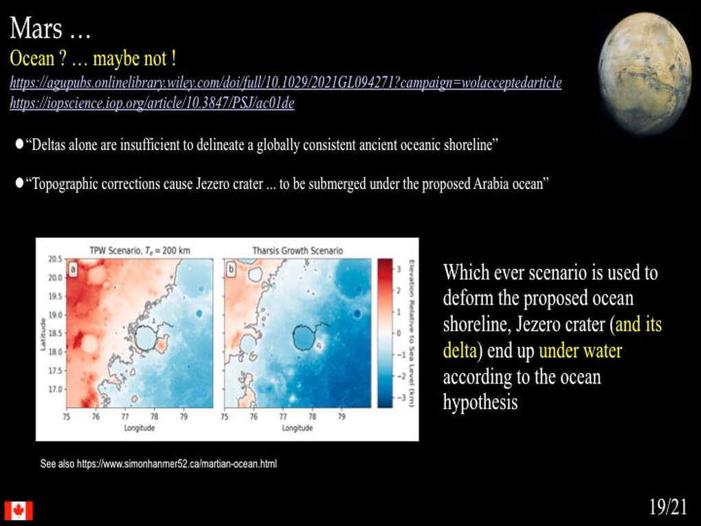
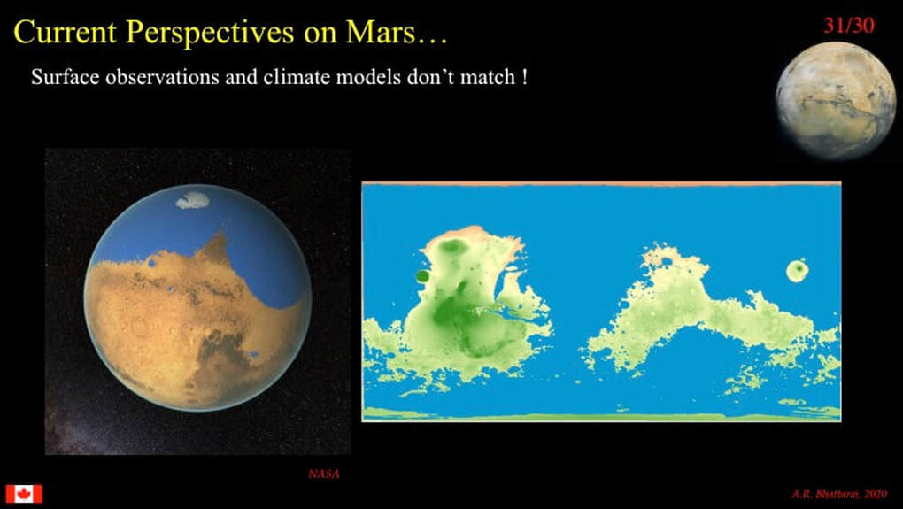
Mars, too, is a hot bed of controversy, but you may be thinking I’m referring to the presence of water : I’m not! I’m talking here about topography. For example, how do you form a rift valley that would extend from Vancouver to Halifax without plate tectonics ? You have to accommodate the “extension” somehow. How do you localise planet-scale volcanism in one place for 2-3 Ga? However, I’m not going to address either of these debates here. Rather, I want to focus on the role of water as an erosional agent responsible for creating major features of martian topography.
The presence of abundant flowing surface water on Mars is a long established fact. The questions related to water revolve around when in martian history and for how long.
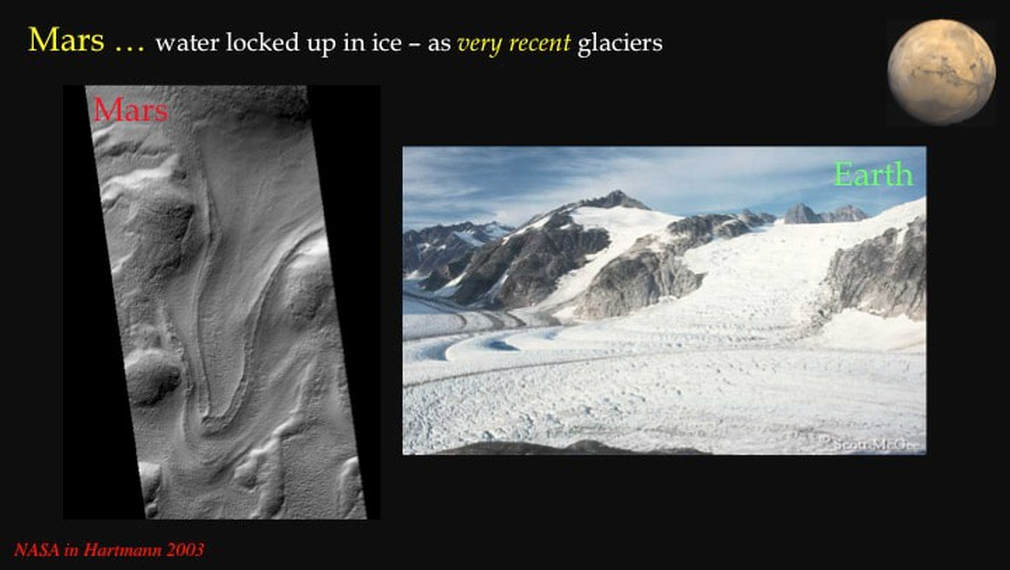
Much of that martian surface water is now locked up as ice, evidence for which is seen here as we compare a glacier on Mars with an equivalent on Earth. Note how few impact craters there are in the martian glacier : it’s geologically young!
I couldn’t resist showing you this comparison pair : they are nearly identical … and there are zero impacts in the martian glacier : it’s very young!
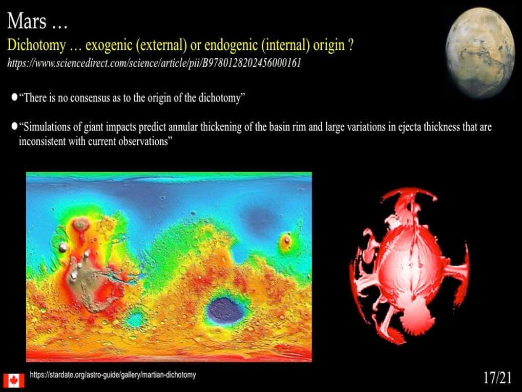
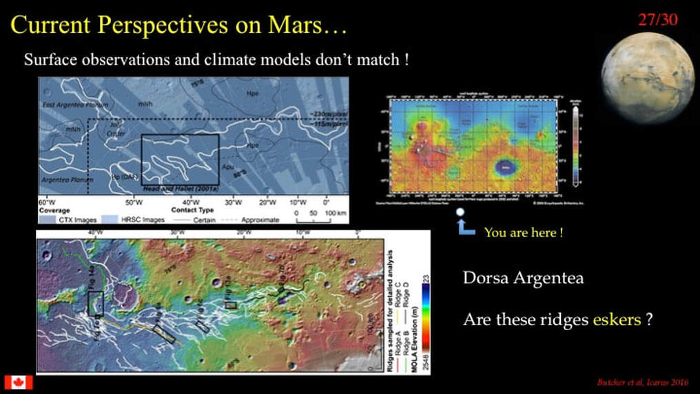
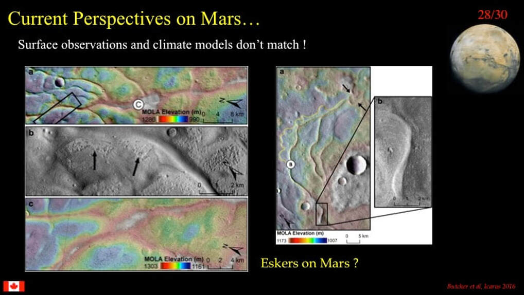
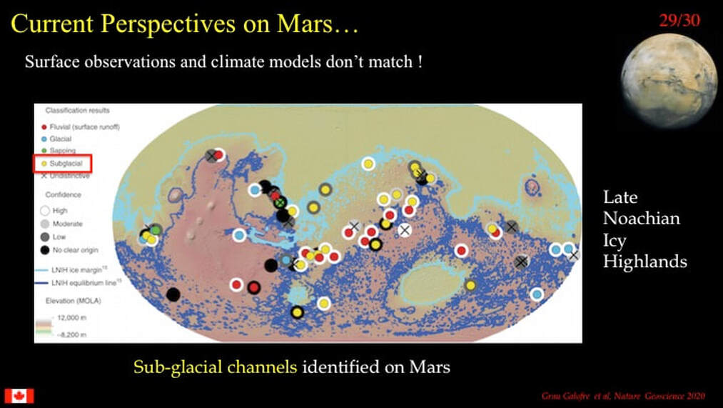
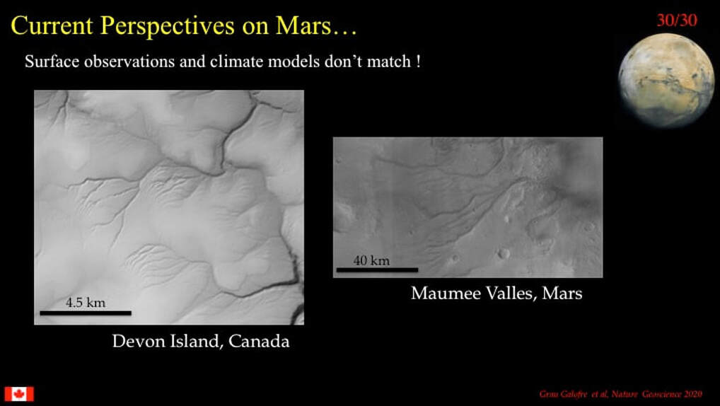
The controversy I want to focus on here concerns the formation of what are known as outflow channels on Mars, 100s to 1000s km long by up to 100 km wide. They occur all along the topographic dichotomy boundary between the Southern Uplands (orange and red) and the Northern Plains (blue) … and are spectacularly developed to the East of the Tharsis Plateau.
Here’s an example. Outflow channels are typically curvilinear with flat floors and very steep sides, such that they resemble shallow slots. Because they have few to no tributary valleys that join them, they are very different from classical river valleys.
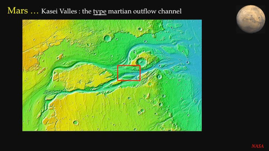
Kasei Valles is the iconic and best described outflow channel on Mars, measuring ~ 2000 km long by over 100 km at its widest part, with steep walls 500++m high. The consensus is that it formed by erosion, by water (although other erosional agents such as runny lavas and debris flows have also been suggested), during catastrophic – i.e. near instantaneous – flooding at some time in Mars’ early history. Since no-one’s ever been to Kasei Valles, what does the scientific community base this interpretation on? Well in part, it’s based on numerical (computer) modelling, which is fine, except that computer modelling provides a test of feasibility – not a test of causality !
The other – universal - justification for the catastrophic flooding model is based on the geology of the outflow channels of the Scablands in eastern Washington state, which by consensus is taken as a direct analogue of outflow channels on Mars. The simplified story here is that ~15,000 years ago, near the end of the last Ice Age, an ice dam holding up Glacial Lake Missoula (whose lake bed has been identified and mapped) broke and the lake (700m deep and the size of lakes Erie and Ontario combined) emptied into the Pacific Ocean by over-deepening and over-widening existing drainage channels – in about a week. That’s catastrophic! All well and good - but think about this for a second. I’m never going to get to Mars to check out this catastrophic flooding hypothesis, but I can drive to Washington state! So, in the Fall of 2014, armed with a couple of excellent guidebooks written by local Washingtonian geologists (Bruce Bjornstad), that’s exactly what I did, setting out from Ottawa !
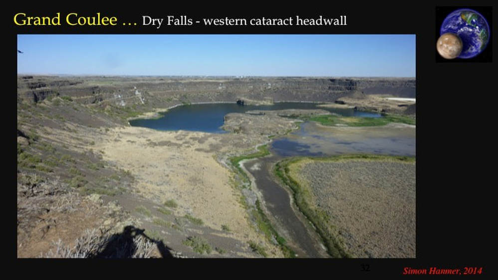
Here’s Grand Coulee, the largest of the Scabland channels that measures just under 100 km long by 1-2 km at its widest. We’re looking directly upstream of the floods. Note the slot-like topography carved in laterally continuous layers of horizontal basalt lava. Remember that most of the martian bedrock is made up of horizontal basalt lava flows. As in the martian channels, those of the Scablands have flat floors, steep sides – up to 100m high in places - and no tributaries. So far, no controversy here, but note that the terrestrial outflow channels are much smaller than those on Mars.
Here’s a view of Grand Coulee looking downstream, that highlights the curvilinear nature of the coulee, as well as the flat floor, steep sides and the horizontal basalt lavas – plus the beautiful weather I had !
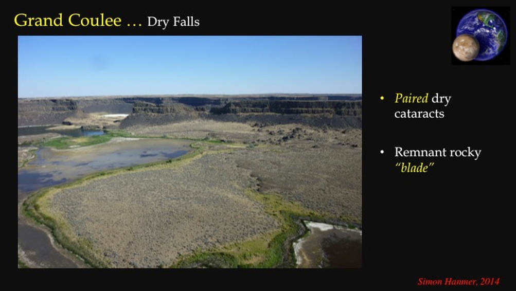
High on the steep sides of Grand Coulee are the Castle Cataracts – here looking upstream. They’re dry now, but ~15,000 years ago water poured over a pair of cataracts (or waterfalls), eroding the headwalls back upstream (away from you) and leaving a narrow “blade” of intact rock between them. Note that one of the cataract headwalls was later breached by on-going erosion. This photo is critical to understanding the formation of outflow channels because, in just about every channel (and there are lots of them in eastern Washington state) you will find paired dry cataracts and their remnant rocky blades. Upstream retreat of paired cataracts is the mechanism that carved out the slot-like outflow channels.
The type example of dry cataracts and remnant blades is at Dry Falls itself, a major tourist attraction. Here we are looking obliquely upstream at one dry cataract headwall, some 50++ m high.
As we swing the camera to the right we can see the second dry cataract, plus the upstream part of the rocky blade, detached by erosion from the paired cataracts. Upstream is to your left …
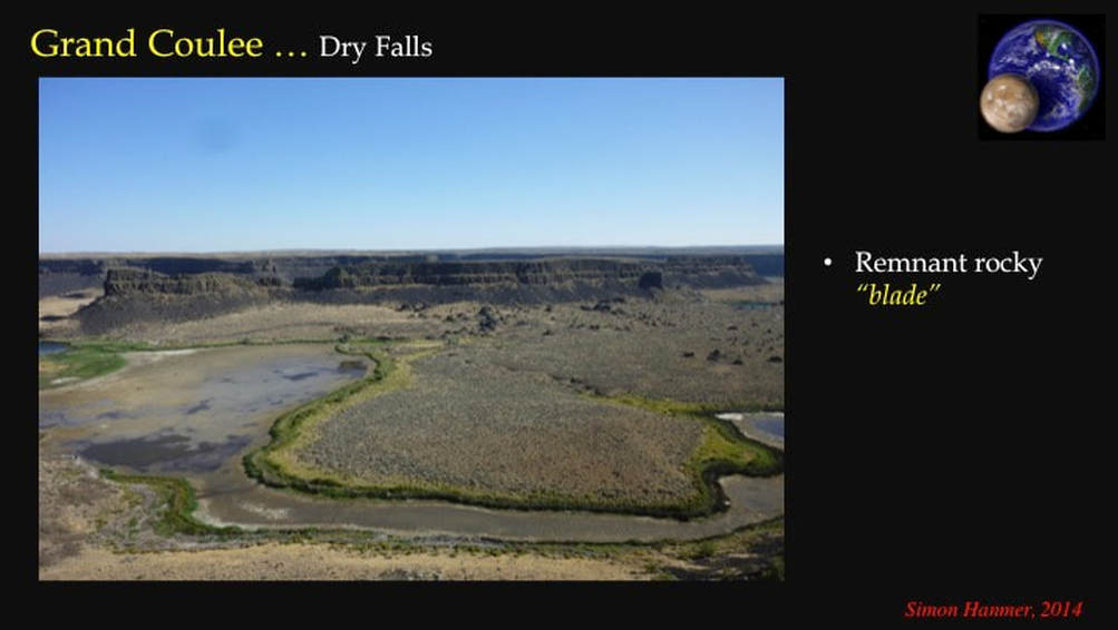
Now, we’ve swung the camera a bit further to the right to frame the kilometre long rocky blade in its entirety, again upstream is to your left and water flowed across your line of sight, parallel to the length of the rocky blade.
How have geologists calculated the depth of the catastrophic flood that carved the outflow channels? Upstream from Grand Coulee is a loosely interconnected network of outflow channels, whose floors are up to 100 m deeper the further you go upstream. Hence the upstream channels had to be filled to overflowing and more, or water could not have flowed downstream. If you now allow for flood water flowing over the extensive flat ground (peneplain) outside of Grand Coulee, you have water depths in the 100s m, flowing at speeds of up to 110 km/hr. Now that’s catastrophic!
How have geologists calculated the depth of the catastrophic flood that carved the outflow channels? Upstream from Grand Coulee is a loosely interconnected network of outflow channels, whose floors are up to 100 m deeper the further you go upstream. Hence the upstream channels had to be filled to overflowing and more, or water could not have flowed downstream. If you now allow for flood water flowing over the extensive flat ground (peneplain) outside of Grand Coulee, you have water depths in the 100s m, flowing at speeds of up to 110 km/hr. Now that’s catastrophic!
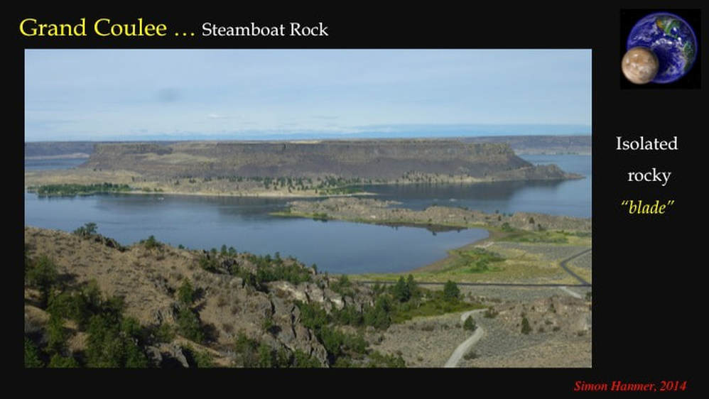
For those who may know this part of the world, here’s the iconic tourist location : Steamboat Rock, identified as a now isolated remnant rocky blade abandoned as its paired cataracts continued to retreat upstream – to your right.
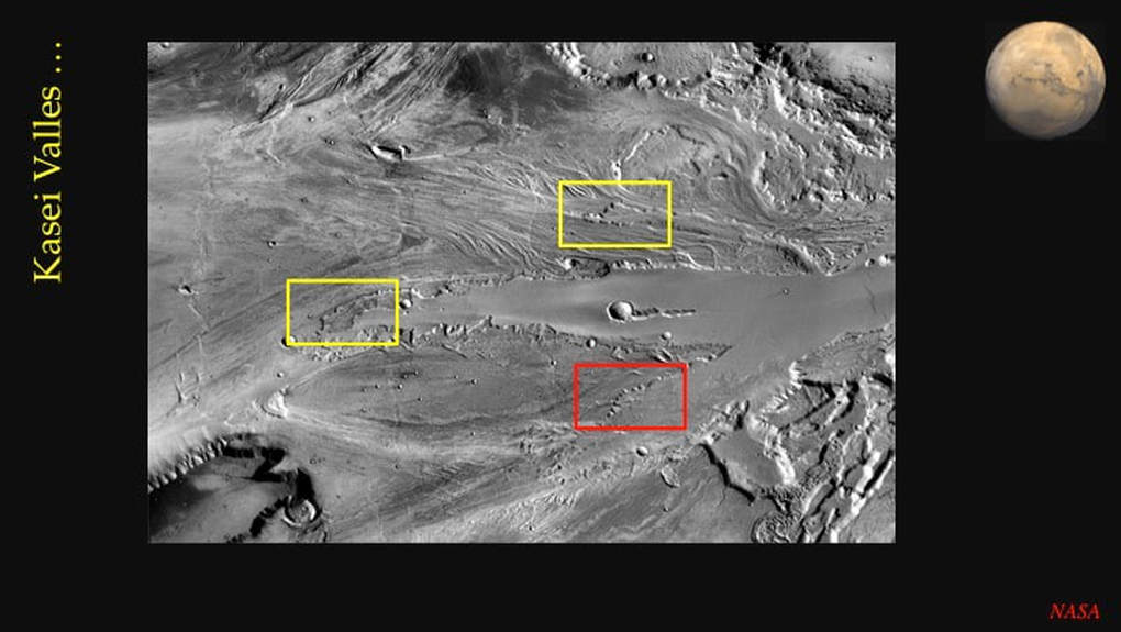
So, having been to “Mars” in Washington … I went back to the internet to investigate the outflow channels on Mars itself. It turns out that – despite the presence of paired dry cataracts and remnant rocky blades all over the Washington Scablands – all of the equivalent evidence is restricted on Mars to one location near the mouth of Kasei Valles. Let’s zoom in on the red box …
There are three locations here with purported multiple dry cataracts and remnant rocky blades, but let’s zero in on the best one – outlined in red.
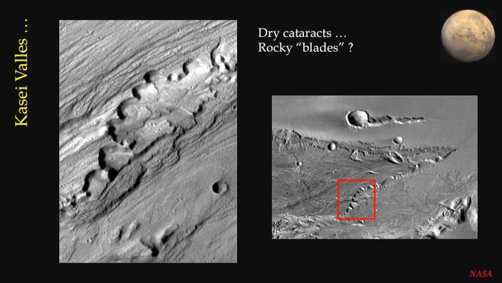
Here we see a series of multiple alcoves, interpreted as dry cataracts some 500 m high, but I only see one candidate rocky blade. If you perform a Google search for dry cataracts on Mars, you’ll get 350 hits - all referring to this same location! So here’s the controversy :
#1 : the evidence for the erosional mechanism (retreating paired cataracts) to form slot-like outflow channels is abundant in Washington state and pretty sparse on Mars. #2 : There is direct observational evidence - more than I have time to describe here – that indicates the catastrophic erosional and carrying power of floodwaters. There is no such evidence on Mars to date. #3 : The size and depth of the martian outflow channels are an order of magnitude greater than that of the largest terrestrial outflow channels, requiring excessively large volumes of erosional water in a catastrophic scenario. In addition, under weaker martian gravity the erosional power of a given volume of water at a given speed is much less than on Earth, so even larger volumes of water are required for a catastrophic scenario on Mars. This is why alternative scenarios have been proposed involving erosion by very runny lavas, or by debris flows made of ~60% water and ~40% sediment. However, these alternatives have not really caught on. So, let’s stick with the water scenario for now
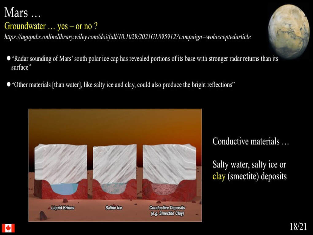
Where might this water come from? The proposed analogy with Lake Missoula doesn’t work : no evidence for lake beds has been found directly upstream of any of the martian outflow channels. The alternative, catastrophic extraction of permafrost as groundwater, is simply unrealistic (analogy: what’s the force of water squeezed from a sponge vs that thrown from an open bowl?). So, while the outflow channels on Mars are undoubtedly erosional, that erosion could be slow and progressive (think Niagara Falls). In short, there is no evidence to support a catastrophic flooding model to create the outflow channels on Mars. NASA and its university-based colleagues have yet to wake up to this!
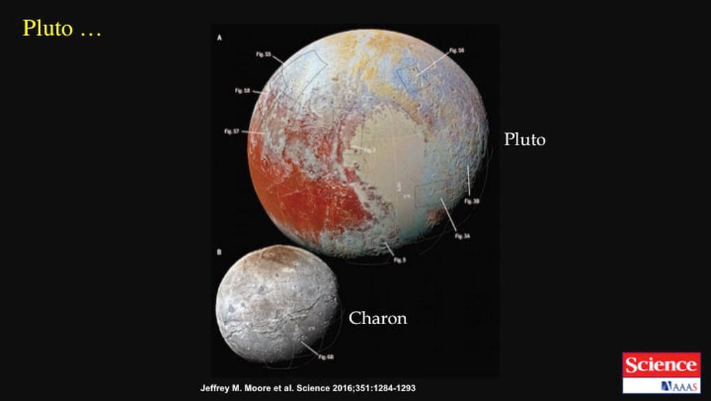
Finally, let’s by-pass the Gas and Ice Giants – and their moons - and head out to the dwarf planet Pluto. The fly-by of Pluto by NASA’s New Horizons probe in 2015 literally shocked the planetary science community. The surface of what was supposed to be an old, cold and dead dwarf planet turned out to have been geologically active during the past 10 Ma, which at the time scale of the Solar System doesn’t even count as yesterday! So the primary Pluto controversy revolves around the origins of the internal heat required for the observed, recent geological activity. It remains unresolved due to a lack of data, so let’s set this issue aside for a few decades to come!
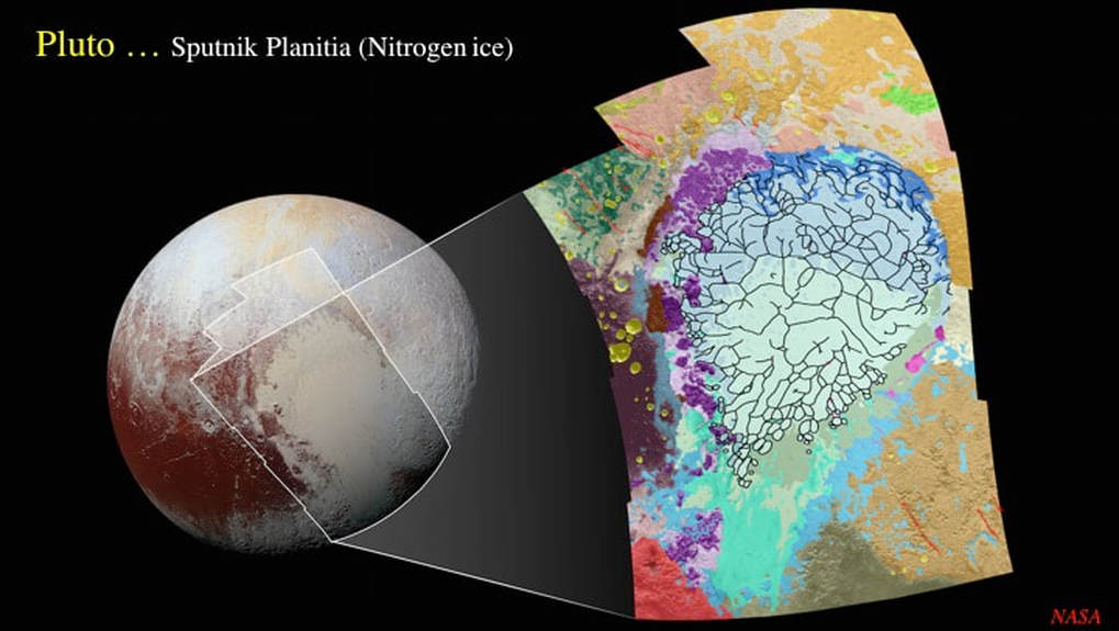
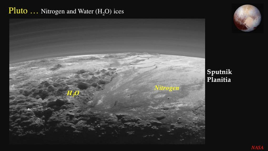
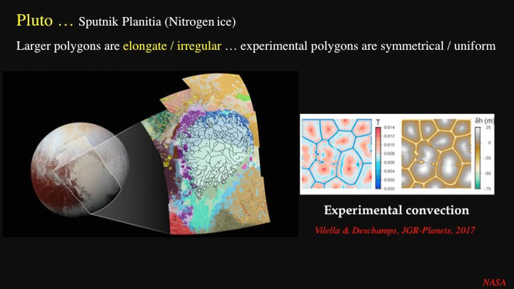
Instead, let’s focus here on another major issue – that I find to be controversial - based on a mix of numerical (computer) modelling, plus some observations and other data thrown in for good measure. To simplify, Pluto’s surface is principally made of two kinds of ice : water and nitrogen. The water ice is mechanically strong at Pluto’s surface temperatures (~30-50° K). It holds up mountains that are kilometres high, and supports abundant impact craters, dating from some 3.8 Ga. Mechanically weak nitrogen ice forms a large elliptical area of unknown age – Sputnik Planitia - with next to no impact craters. According to the traditional cratering statistics model, this would imply that the surface of Sputnik Planitia is no older than 10 Ma. However, if nitrogen ice is too weak to support the topographical relief of impact craters, the cratering statistics model does not apply and the surface could be any age … including ancient! Before we leave this map …notice how the nitrogen ice of Sputnik Planitia is divided into a network of polygons up to ~100 km long by 10’s km wide.
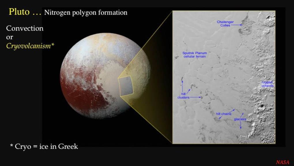
This is what the two ice terrains looked like from the New Horizons probe, as it flew by at 60,000 km/hr.
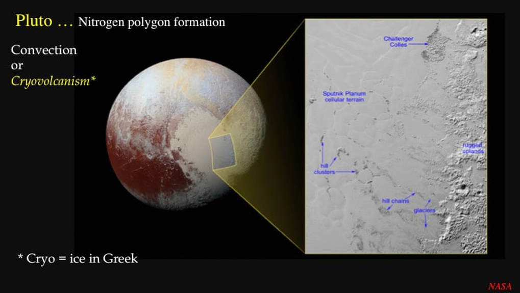
NASA and its university-based associates interpret the polygonal nitrogen ice according to a debateable glacier model. Starting with a pre-existing glacier, NASA and associates then use computer models to hypothesise that the polygons in the Nitrogen ice are manifestations of thermally driven convection … think lava lamps, if you’re old enough to remember them! According to this model, each polygon is therefore a convection cell wherein nitrogen ice, heated from below, rose to the surface of Sputnik Planitia and then spread laterally, before cooling and sinking at the polygon margins.
BTW : for this “heated-from-below” convection model to work, a value of heat flow from within Pluto has to be assumed : there are no data. So another research group has recently suggested that maybe the convection in the nitrogen ice is driven by cooling from above. It’s a neat idea, but it still doesn’t manage to produce the variety of polygon shapes we observe on in Sputnik Planitia.
OK, let’s get back to the previous image. Notice the dark bits and pieces scattered through the marginal nitrogen ice. NASA and associates interpret these as icebergs, 3+ km high, of water ice that is buoyant in nitrogen ice at Pluto’s surface temperatures – provided that the nitrogen ice is solid. Applying the convection model, they go on to suggest that the floating icebergs were swept to the polygon margins by the convective flow within the polygons, where they form isolated hills, hill chains and hill clusters. But here’s the problem: this is a dead-end line of reasoning. We’ve all heard the expression “the tip of the iceberg”; well, it applies here too. The hidden part of icebergs 3+ km high requires the nitrogen ice to be 10-15 km thick in order for the icebergs to float. However, on Pluto, at greater than 2-3 km thickness, it melts and decreases dramatically in density, such that water ice will no longer float in it. More recent scientific papers recognise this problem, yet they still propose that the supposed water ice ”icebergs” are moved by convecting nitrogen ice while dragging and scraping along the bottom of Sputnik Planitia. Icebergs do not behave this way! They then go on to derive the supposed “icebergs” by having them slide downhill carried by mountain glaciers of nitrogen ice from the heights of the ancient cratered water ice highlands that bound Sputnik Planitia! However, the mountain glaciers are less than 5 km wide and the supposed “icebergs” can measure up to 40 km across(!), as in the case of Challenger Colles.
This is where I’m going to be the source of controversy : let’s speculate wildly here. What if the purported “icebergs” of water ice were not mobile? What if they are in fact islands still attached to the rugged water ice uplands seen here on the right? One recent paper does indeed refer to one water ice hill as a “Nunatak”, but goes no further. What if the nitrogen ice is indeed solid throughout and therefore no thicker than a few km? What if the hill clusters and hill chains indicated here are in fact the visible parts of partially drowned peninsulas of water ice – thereby accounting for their apparent alignment near perpendicular to the margins of Sputnik Planitia ?
What if the narrow polygon margins were not the sites of down-welling flow? What if the polygons in the nitrogen ice are not convection cells at all? What if they are multiple volcanic – that’s to say cryovolcanic ice lavas erupted from Pluto’s interior (some scientists have suggested such a source for the nitrogen ice)? That would make Sputnik Planitia a giant composite volcano. Nitrogen ice may be dense, but it’s mechanically very weak on Pluto so you would not expect it to build tall volcanic edifices: think of the extremely runny lavas on Io - where volcanoes are not mountains and mountains are not volcanoes. What I am suggesting here is indeed controversial … but it’s as good as anything NASA and company have put on the table to date!
Well this brings me to the end of my presentation, but before I draw things to a close I’d like to simply list - with a minimum of explanation - my further geological perspective on what we should be doing next to advance our understanding of the Solar System we inhabit.
Mercury : We should explicitly ask: how did it acquire a relatively oversize Fe-Ni core and what does that require in terms of an overhaul of our model(s) of Solar System formation?
Venus : Starting with the Earth, we must openly debate and evaluate our model(s) of planetary mantle structure (mixing) and convection dynamics, after which Venus specialists have to come out of their bubble and talk to other scientists about how best to interpret Venus’ surface features.
Mars : Stop sending costly rovers to the martian surface. The major scientific break-throughs concerning Mars have all come from orbiting platforms with their high resolution cameras and remote sensing tools. If we want to land on Mars, send an array of seismological instruments. The only way we will ever get to explain continuous static volcanism that lasted 2-3 Ga – a fundamental feature of the red planet and truly unique to Mars - is to get a good picture of the martian interior … and that could require 10s of monitoring stations, at the very least.
Pluto : Well, what can I say? We’re clearly not going back there any time soon, so don’t hold your breath for new data. I guess we’ll have to continue with the computer modelling, some of which is really very good. I just wish they would talk to some geologists!
Proudly powered by Weebly
