|
NEW HORIZONS FLY-BY @ PLUTO
|
When NASA’s New Horizons probe performed its fly-by of the Pluto-Charon system exactly 12 months ago, I gave a presentation to the RASC Ottawa chapter where I discussed the already exciting, not to say surprising, preliminary images in a talk that I subtitled "Geological Speculations Based on Minimal Data". Most of those initial images were relatively low resolution (kms/pixel).
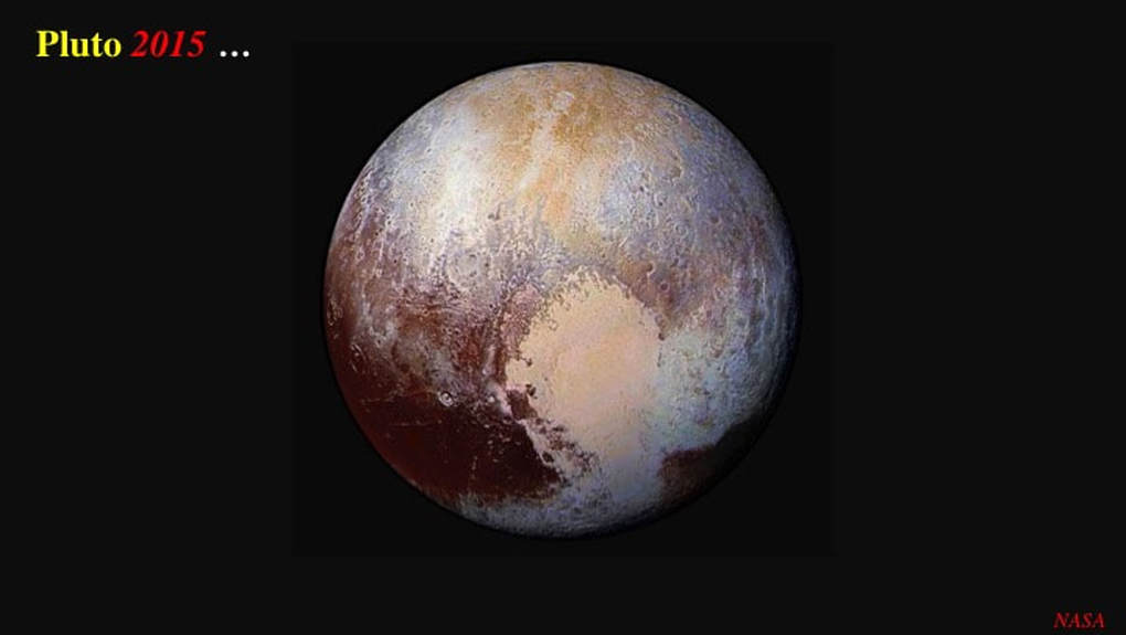
This how we saw Pluto in 2015, and the big excitement at the time was that the surface was clearly recently geologically active. A large heart-shaped area of smooth – therefore young - predominantly nitrogen ice, no older than ~10 Ma, overlies older water ice with abundant impact craters. This requires that the insides of Pluto are currently hot enough to at least partially melt ice in the frigid conditions of the outer Solar System (~30-50°K), which raised the still unanswered question : What is generating the internal heat in a dwarf planet that was supposed to be old, cold and dead ?
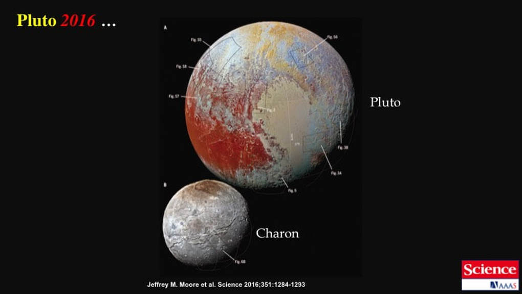
Since that presentation, the New Horizons probe has successfully transmitted its high resolution data (0.1-1.0 km/pixel), giving us a very clear picture of what the imaged parts of Pluto - and its moon Charon - would have looked like to a well equipped astronomer onboard the New Horizons space craft (perhaps with binos and/or a small scope).
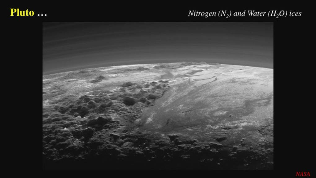
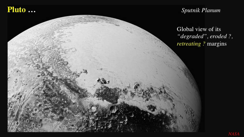
NASA has now released a wealth of selected and processed data into the public domain, principally in the form of superlative images, such as this detailed illustration of the young, low-lying, impact-free N ice field (Sputnik Planum) and the older rugged water-ice highlands … as well as Pluto’s beautifully stratified atmosphere.
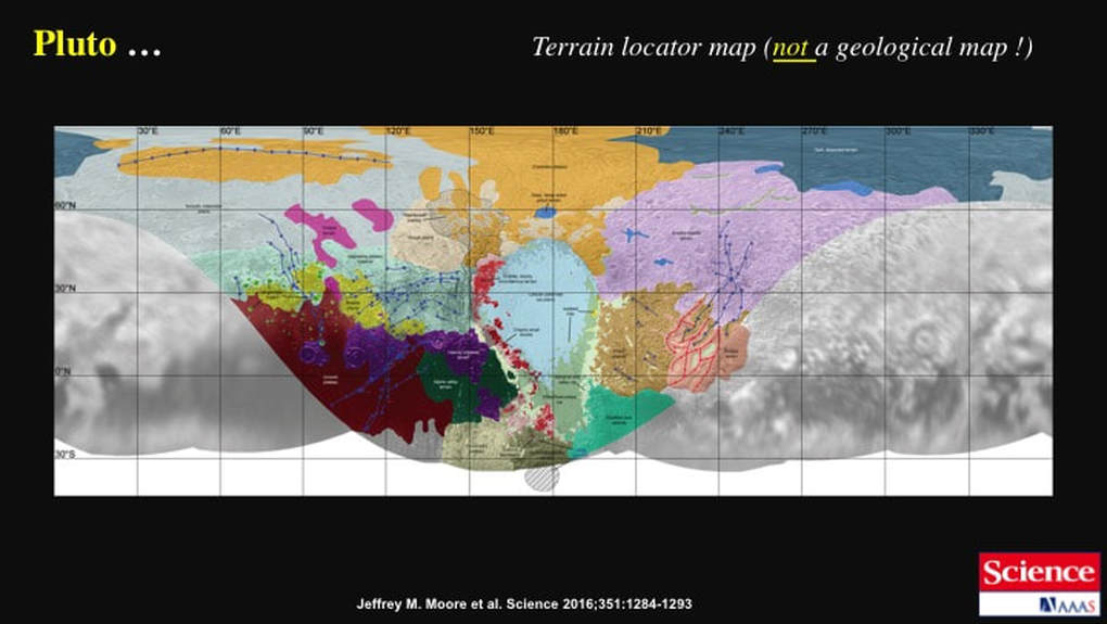
Associated university-based planetary scientists have now started to publish tentative interpretations of what it all means. Most importantly, a set of six papers was published earlier this year in the highly reputable magazine Science, and they’re available to the general public on-line. This image serves two purposes here : First, to point to a few key locations and their names, and second to illustrate the difference in photographic resolution between the area imaged during closest approach and the rest of Pluto that was imaged from much greater distances.
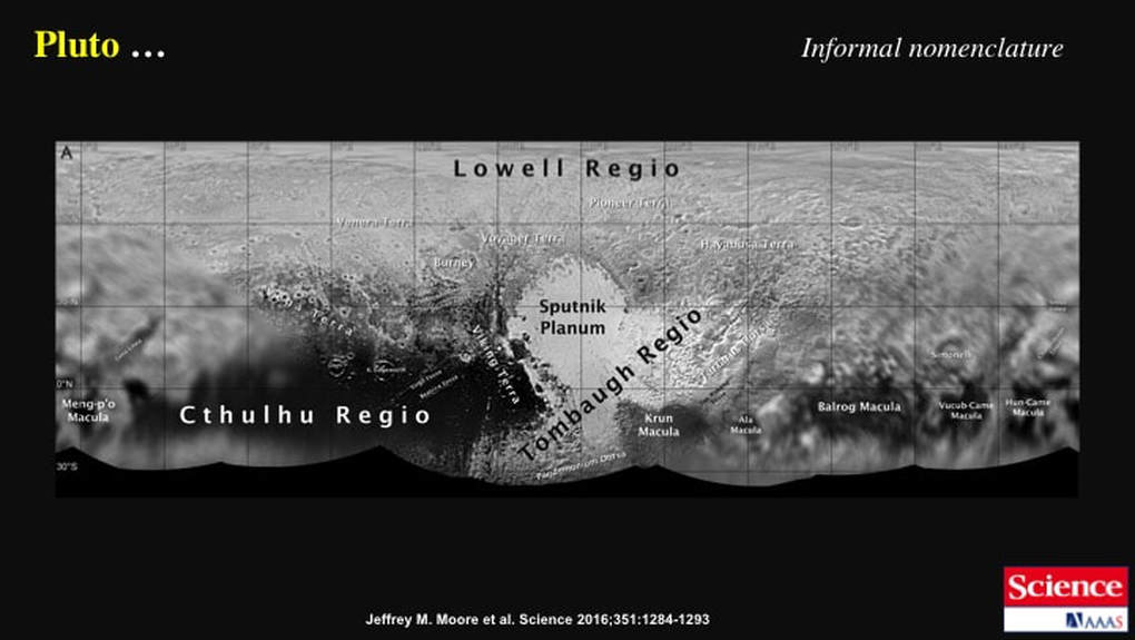
Much of the scientific work that’s now in the public domain continues to focus on the source of internal heat within Pluto. However, so much of this effort is highly speculative : no-one has any data to work with. So, here I’m going to focus on the features we can observe directly thanks to the new high-resolution imagery, features we can attempt to interpret for ourselves and compare with what the professionals are saying about them. NASA and its associated scientists have done a great job of mapping and classifying the different terrains, nicely illustrated in this image. However, while they’re arm-waving about Pluto’s internal heat, they remain somewhat cagey when it comes to interpreting the visible surface features. Here’s a case in point : as the authors of this article clearly state, this is a terrain locator map, not a geological map. That means it’s an inventory of colours, shapes and textures as opposed to an interpretation of processes and their significance or meaning.
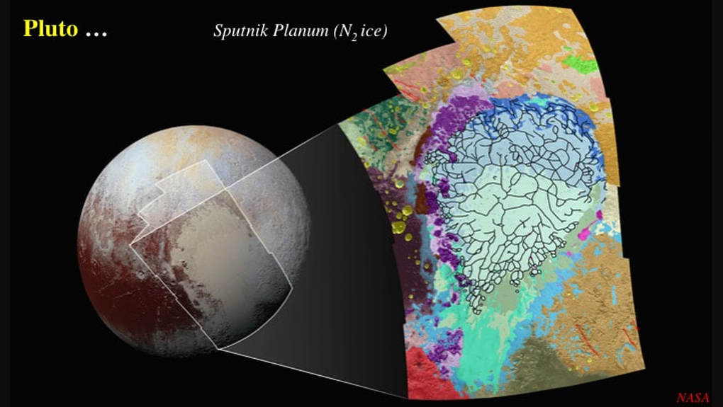
As a prime example of what I mean, let’s look at Sputnik Planum. A year ago, we already knew that it was made of nitrogen ice divided into large polygons, up to ~100 km long and ~10s km wide. Since then, NASA has released a number of highly detailed images of the Sputnik Planum nitrogen ice field, with emphasis on its margins and its internal polygons, and planetary scientists have been deriving numerical (computer) models to explain it. Let’s take a look …
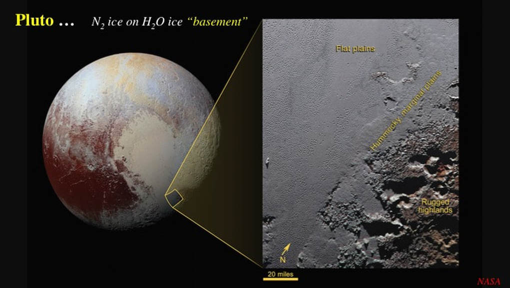
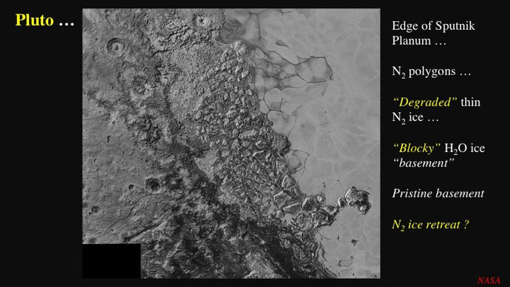
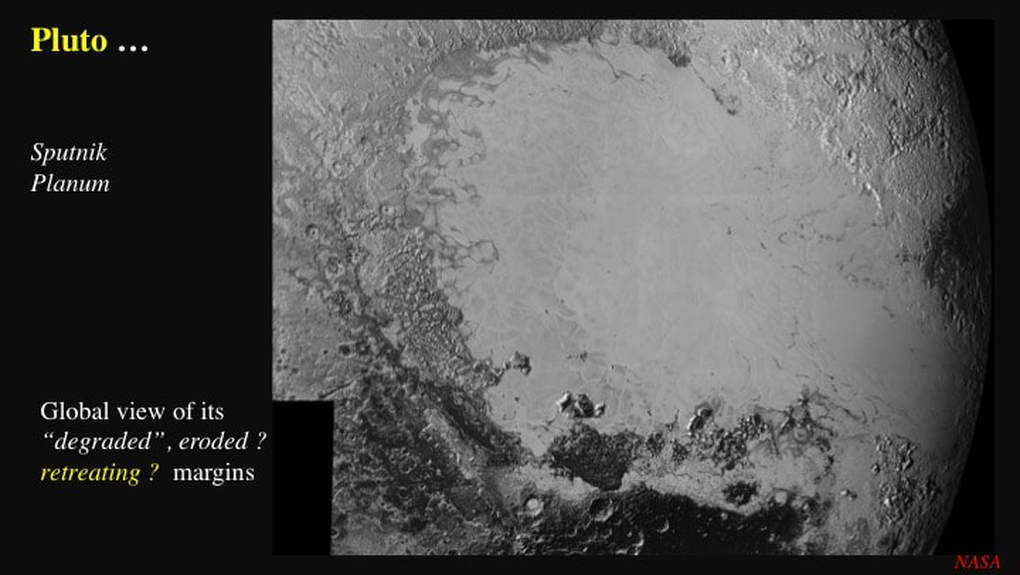
Here’s a nicely detailed image of part of the boundary between the smooth Sputnik Planum, made of mechanically weak nitrogen ice, and the rugged highlands, made of mechanically stronger water ice. It’s pretty clear that the nitrogen ice gets progressively thinner as one approaches the highlands, and that it sits on top of them. So, we can talk of a nitrogen ice "cover" over the top of a water ice "basement". You can make out "headlands" and "bays" at the edge of what NASA has labelled "hummocky marginal plains". I don’t know about hummocky : I would call it blocky, but we’ll come back to this in just a minute. These promontories will be an important observation later in the presentation - so take a good look at this image and keep it in mind.
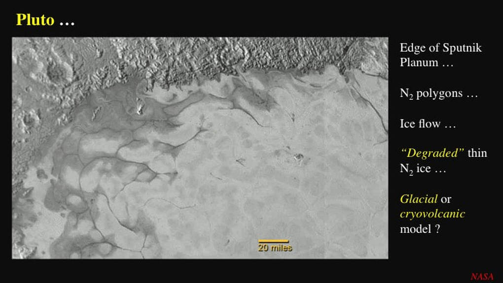
This NASA image dates from July 2015. Already it was clear that nitrogen ice has flowed from the interior of Sputnik Planum toward the highlands : this is especially clear at upper left. You can see the polygonal shapes within the nitrogen ice, especially well highlighted toward the edges of the young ice field. Notice how dark grey the nitrogen ice is around the margins of the ice field : it appears to be altered as it gets thinner. Anyone who has worked with fixed-wing aircraft landing on still frozen lakes in Northern Canada during the spring will recognise this : the ice is degraded and weakened : less coherent than where it’s thicker in the interior. This also might also explain why the boundaries of the polygons are so easy to see in the marginal areas. It’s intriguing that, while planetary scientists have noted the colour change at the margins of the nitrogen ice field, they’ve not provided any interpretations … yet ! Flow of a sheet of weak nitrogen ice over a strong water ice basement could be explained by either of two processes : glacier flow, or cryovolcanic flow (volcanism involving mobile ice).
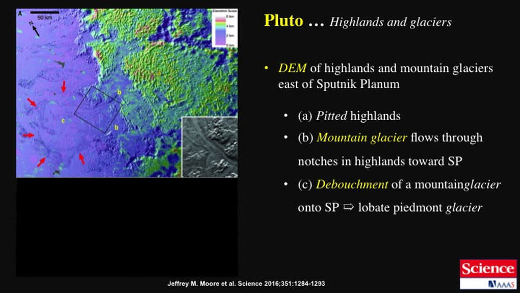
Last year NASA and its associated planetary scientists decided upon a glacial model that they’re still promoting, and this is part of their evidence. They suggest that these linear and lobate features indicate that the nitrogen ice accumulated in the highlands and flowed as mountain glaciers down onto Sputnik Planum. However, there are two problems here. First, there are no ice fields up in the highlands (i.e. no relict sources for purported mountain glaciers) ; and second, given Pluto’s thin atmosphere, it is not obvious how to build the purported nitrogen ice glaciers in the first place. Nitrogen rains out of Pluto’s atmosphere as frost, not as thick accumulations of snow ! Last year, I found NASA’s interpretation to be highly speculative, and a cryovolcanic process, sourcing mobile ice from within the dwarf planet made most sense to me. Well, with the new high resolution images, it turns out you can have your cake and eat it too : we could all be right, at least in principle. I’ll get to that in just a minute, but first, some more observations.
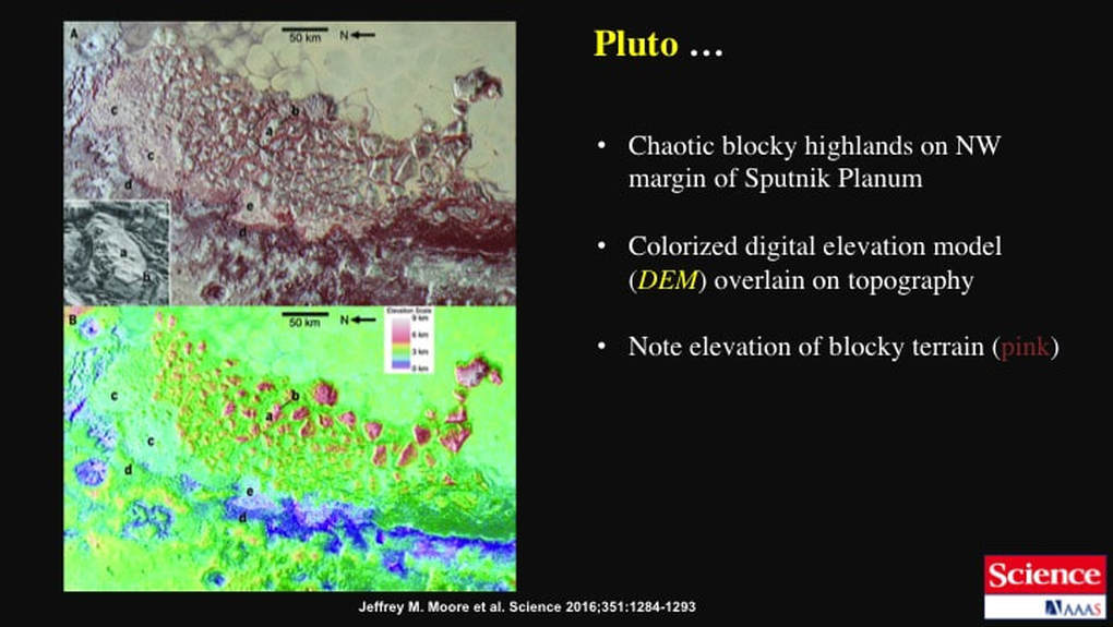
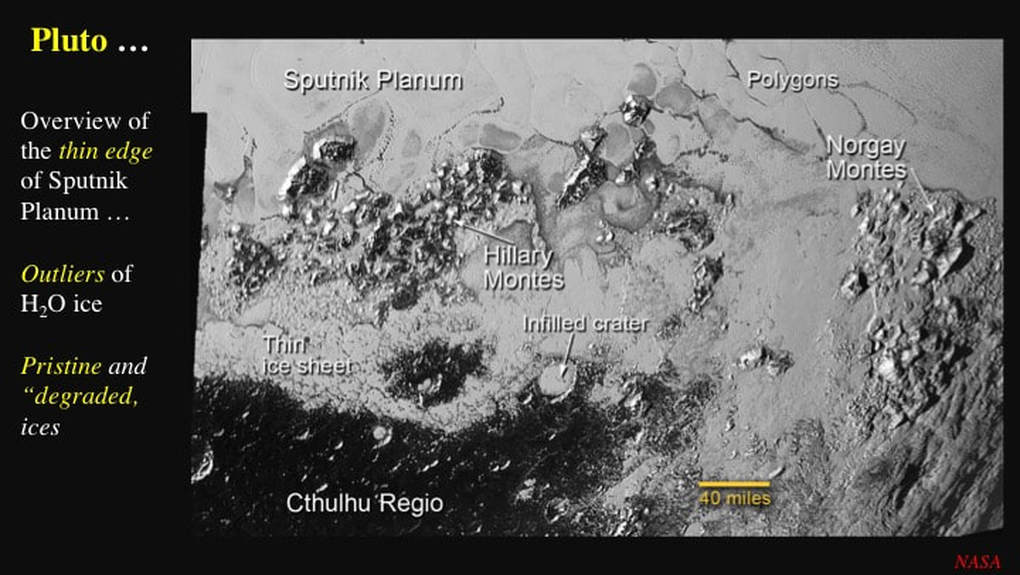
In this detailed image of the margins of Sputnik Planum, we see the pristine water ice highlands basement to the left, and the white polygons of N ice to the right. Running down the middle of the image we see a swath of chaotically (randomly) blocky basement with blocks 10s of km in diameter, bordered to its right by degraded, thin nitrogen ice. We know the nitrogen ice is thin because we can see peninsular islands or "outliers" of blocky water ice surrounded by it. Once again, we see that the nitrogen ice is a cover sequence over the water ice basement.
This is the same image, but with a digital elevation model (DEM) that illustrates how the blocky terrain forms higher elevations than either the pristine water ice terrain or the nitrogen ice of Sputnik Planum.
So, how do we explain these observations ? Planetary scientists suggest that the very young (less than 10 million years) nitrogen ice of Sputnik Planum may fill a very old (~3.8 billion years ?) impact basin, similar in age and nature to those we observe on our own Moon. However, they then get equivocal and couch things in the conditional. They cautiously intimate that the blocky highland terrain we see rimming the western edge of Sputnik Planum in this image is related to an impact basin. However, impact basins are multi-ring features resulting from initial cavity collapse – and I know of none in the Solar System that formed localised impact breccias with blocks up to 40 km across and 5 km high, as in this image. A year ago, I speculated that the blocky margins of the water ice highlands might represent chaotic "weird terrain" resulting from the global refraction and focusing of forces from a massive impact on Pluto’s unseen far side, the type example being on Mercury, dead opposite the Caloris impact basin … and weird terrain can contain blocks this size. In addition, weird terrain is usually irregular in shape, as opposed to circular impact basins, possibly providing an explanation for the otherwise puzzling absence of blocky highland terrain at the eastern edge of Sputnik Planum. Planetary scientists then go on to suggest that the nitrogen ice was originally thicker than today, and therefore extended further onto the blocky highlands. Furthermore, they speculate that the nitrogen ice may have played an ill defined role in modifying the blocky highland terrain through a combination of undercutting, floatation (water ice floats in nitrogen ice) and rotation. They then go on to suggest that, at some later time, the nitrogen ice retreated, possibly by sublimation, which also led to degradation of the nitrogen ice - exposing the water ice basement with relict patches of nitrogen ice. The blocky water ice highlands were then modified by glacial erosion as the nitrogen ice flowed from the relict patches, down to the edges of Sputnik Planum.
What I take from all this is that impact-related weakness in the water ice basement – possibly in a weird terrain setting – may have localised much later eruption of nitrogen ice from Pluto’s interior. Nitrogen ice retreat by subsequent sublimation exposed the marginal water ice highlands that were "etched" by erosion when relict nitrogen ice flowed as mountain glaciers onto Sputnik Planum. In other words, formation by cryovolcanism was the main Sputnik Planum event, followed by minor modification by glacial flow.
Let’s now turn our attention to the polygons in the nitrogen ice of Sputnik Planum. Planetary scientists have looked at the polygons using numerical (computer) modeling as their primary tool. In so doing, they propose that the polygons may be the tops of large, recent, convection cells in nitrogen ice that was warm enough to rise in the polygon interiors, flow outward at the surface, and cool enough to sink along surprisingly narrow margins. However, here’s the problem : you can fine tune – or over-constrain -computer models to produce the result you seek. Thermal convection is highly dependent on heat flow from below, and we don’t know what the heat flow of Pluto is. In addition, convection geometry (polygon size and shape) is dependent on the thickness of the convecting material, and we don’t know how thick the nitrogen ice is. So, planetary scientists have had to make assumptions in order to run their computer models, That’s fair enough as a test of feasibility, but it is not a test of causality ! So, bearing these caveats in mind, lets’s take a closer look at what’s been going on in the polygons.
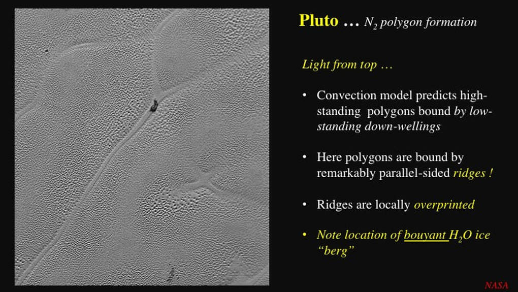
The convection model - something I have a lot of personal hands-on experience with in a geological context - as calculated by planetary scientists, predicts that the upwelling interiors of the nitrogen ice polygons in Sputnik Planum stand about 10m higher than their downwelling margins. The well established standard model for convection cells predicts that the downwelling areas should form broad troughs (think Coronae on Venus), but in most of Sputnik Planum the polygon margins are not broad troughs, they are unusually narrow and parallel sided. However, take a closer look at this image. The polygon interiors are pervasively covered with small ~1-2 km diameter pits, very likely the result of sublimation, though I have no explanation for why the sublimation would form such a uniformly distributed texture - nor does anyone else, by the way. In fact the observation is generally ignored ! Now look at the pits. Illumination of their walls indicates that the Sun is shining from the top of the image. Highlights and shadows demonstrate that the purported downwelling margins of the polygons are ridges - not troughs - though this is not the norm for much of Sputnik Planum. Planetary scientists have not ignored this, but they describe median ridges in troughs, similar to the triband linear structures I told you about on icy moons of the outer Solar System a couple of years ago, which is clearly not the case here. Now look at the pattern of ridges at the polygon margins. In places they have lost their relief, and subsequently been overprinted by sublimation pits. Hence we have a time sequence - purported convection cells first, and sublimation second. Note : the same observations apply to the more normal marginal troughs throughout Sputnik Planum. How did the ridges lose their relief ? If they’d collapsed under their own weight by viscous relaxation then they should have spread laterally - become wider – however, that is not what we observe. What’s going on here ? I don’t know, but what if the ridges were dense enough to sink vertically back into the surrounding ice ?
Finally, notice the small black "pip" in the image. Planetary scientists suggest that it is a block of bouyant water ice, detached from the margins of Sputnik Planum, floating like an iceberg in the denser nitrogen ice. Possibly so, but notice its location : its very specific - it sits at the intersection, or triple-point, between three polygonal convection cells. For the structural geologist that I am, this sets off alarm bells !
Finally, notice the small black "pip" in the image. Planetary scientists suggest that it is a block of bouyant water ice, detached from the margins of Sputnik Planum, floating like an iceberg in the denser nitrogen ice. Possibly so, but notice its location : its very specific - it sits at the intersection, or triple-point, between three polygonal convection cells. For the structural geologist that I am, this sets off alarm bells !
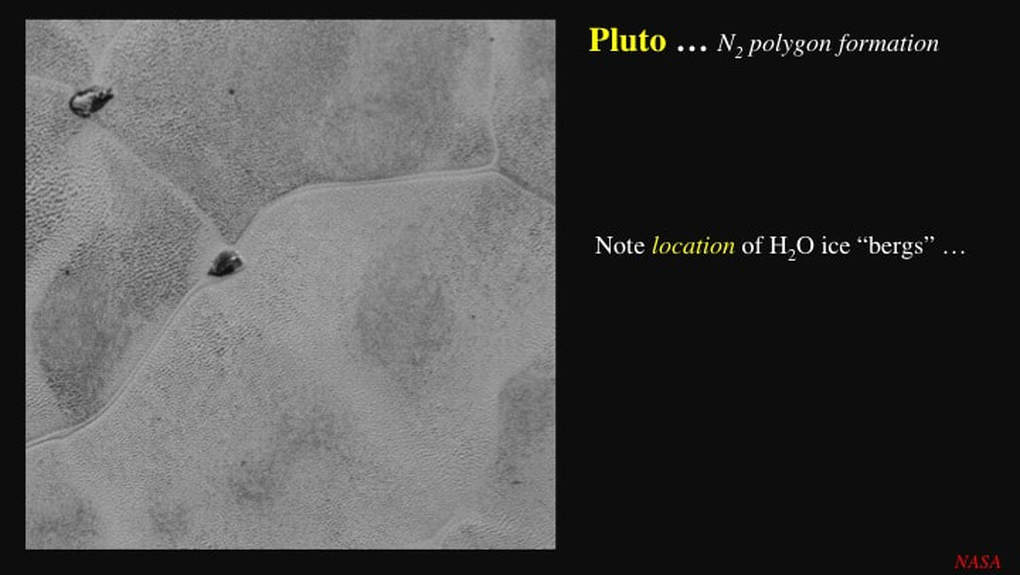
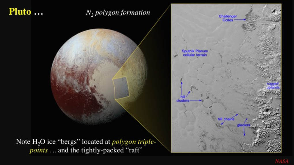
Alarm bells that are supported by this image of two "icebergs", both located at triple-points. I’ll come back to thisobservation in a minute, but first let’s look at more of these supposed icebergs.
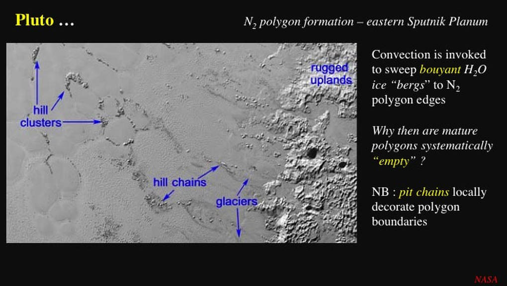
Planetary scientists present this annotated image from eastern Sputnik Planum as evidence that floating bergs of water ice, up to 3 km high and more, derived from the adjacent rugged highlands, are carried by the horizontal flow of spreading convection cells in the nitrogen ice to the polygon margins to form "hill chains" and "hill clusters". On the basis of this model, knowing that most of any iceberg is submerged, they then estimate the thickness of the nitrogen ice of Sputnik Planum to have been around 15 km in order for the icebergs to have floated. Given that this is a bit steep even for an impact basin, they then speculate that the load of the nitrogen ice itself could depress the floor of the initial impact cavity to make up the shortfall. However, this line of reasoning is a dead end because, as the planetary scientists themselves point out, beyond a few km thickness nitrogen ice melts and its density drops dramatically - such that water ice would not float in it. But all this is pure speculation by NASA and its associates. So, now its our turn to speculate !
What if the ice mountains are not icebergs at all ? What if they are islands, mountain peaks still attached to the underlying water ice basement beneath Sputnik Planum ? Notice how to the upper right there are "hill chains" of the same orientation as the labelled ones, but in the absence of any evidence for polygons. Notice also how all the "hill chains" are parallel to each other and oriented at a high angle to the nitrogen ice/water ice boundary : the same orientation as the water ice promontories we saw in an earlier slide that I asked you to remember.
What if the ice mountains are not icebergs at all ? What if they are islands, mountain peaks still attached to the underlying water ice basement beneath Sputnik Planum ? Notice how to the upper right there are "hill chains" of the same orientation as the labelled ones, but in the absence of any evidence for polygons. Notice also how all the "hill chains" are parallel to each other and oriented at a high angle to the nitrogen ice/water ice boundary : the same orientation as the water ice promontories we saw in an earlier slide that I asked you to remember.
Let’s now stand back and look at the big picture on the east side of Sputnik Planum, and evaluate the iceberg model for ourselves. I make the following key observations. First, we can now see that the "hill chains" are not chains at all. They are elongate to equidimensional clusters of water ice with an identical pitted texture to that seen in the adjacent rugged highlands. This includes Challenger Colles that has been interpreted as a large iceberg cluster that ran aground in shallow nitrogen ice - though it’s also been compared with "chaotic terrain" on Europa, in the same paper ! Second, over half of the isolated water ice "mountains" are located at triple-points where three polygons meet, and few to none of the water ice "mountains" occur within the polygons.
Let’s now try and piece this all together, with some wild speculation on my part ! What if the nitrogen ice polygons are not the product of convection due to the heating of the base of Sputnik Planum at all ? What if the polygons are individual extrusion events : the consequence of melting within Pluto, the rise of cryovolcanic magma (ice !), and its emplacement into the growing Sputnik Planum ice field as a sequence of multiple, flattened bubbles ? What if the horizontal surface flow, associated with the flattening of multiple, synchronous, rising bubbles of cryovolcanic nitrogen ice, was pinned by the drowned water ice outliers or island clusters ? In that case it would be the polygon margins that were mobile and the water ice islands that were static, rather than the other way around. Why would the triple-points in the polygon boundary network get preferentially pinned by isolated water ice islands ? I’m not sure, but this is exactly what you see in mineral aggregates and foam bubbles, where the driving force is the reduction of surface energy by the presence of impurities. Could this operate in nitrogen at this large scale ? I don’t know.
If my wild speculations here have any validity, they imply that the margins of the nitrogen ice polygons are not the sites of downwelling convection : they are simple interfaces between different directions of horizontal ice flow. They imply that we are not looking at a convection cell model driven by heat from below at all. Instead we are looking at cryovolcanism driven by the heat of low viscosity (very runny) magma (ice) erupting onto Pluto’s surface. In short, the polygons can be seen as individual volcanoes and associated lava flows of very runny ice magma. Why are there no classical volcanic edifices ? Think of the runny lavas of Io. Finally, according to my speculative model, the nitrogen ice of Sputnik Planum could be no thicker than 2-3 km, assuming that it is solid throughout.
What about the volcanic edifices Wright Mons and Piccard Mons, shown here ? They even look like volcanoes ! Correct, but they are made of mechanically strong water ice – and they are the only two volcanic edifice candidates so far identified !
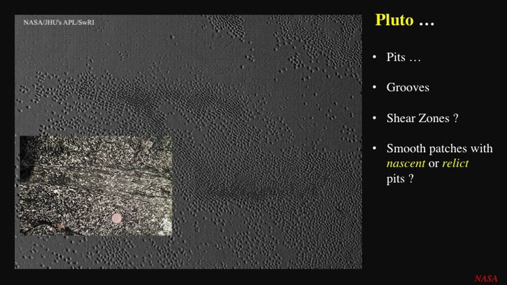
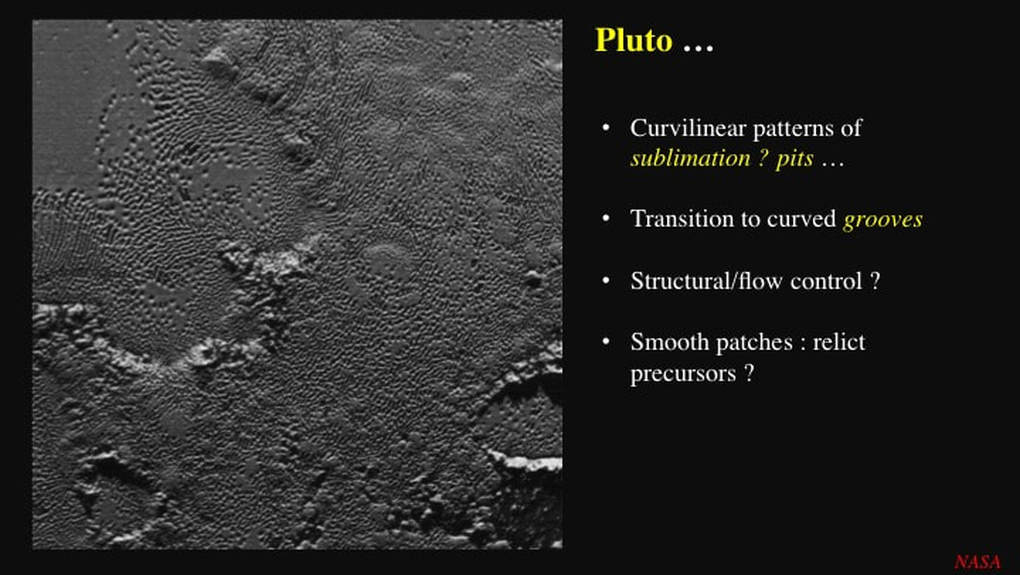
I’ve mentioned sublimation numerous time here. So what’s the visual evidence that sublimation has been - and likely still is - a widespread process on Pluto ? Here we see that ~1-2 km diameter pits are pervasively developed in ice, and in several patches they form curvilinear pit chains that coalesce to form curvilinear grooves. As a structural geologist, I see two belts trending left to right, with the grooves curving progressively across them. The inset is a very famous rock from Scotland (note the scale). It shows similar curvilinear features developed across a smeared-out band in an otherwise undeformed rock : this feature is called a shear zone. The shear zone formed when the rock on either side slid sideways and squished the stuff in the middle. The sense of curvature (an "S" shape) of the newly developed fabric in the rock tells me that the upper part of the image slid left with respect to the lower half. It may be much smaller than the example from Pluto, but I suggest the two formed the same way. The ice was sheared by differential flow within the ice itself, creating a fabric made of planes of weakness that localised more intense sublimation – initially in pit chains that coalesced to form grooves - along the shear zone fabric.
If the smeared out part of the shear zone gets subsequently deformed by further ice flow, then the belt of pit chains and grooves itself ends up curvilinear (folded shear zone), as seen here to the upper left.
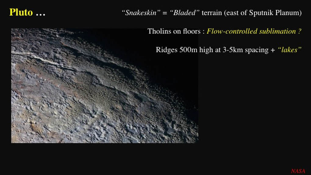
In this example, the aligned grooves are now pervasive and quite deep. Notice what we see on the floors of the grooves : a reddish deposit of tholin, a complex hydrocarbon that forms a residue when ice that contains it sublimates, and leaves the tholin behind. This is visual evidence of sublimation. I find it intriguing that NASA and its associated planetary scientists only refer to this obliquely !
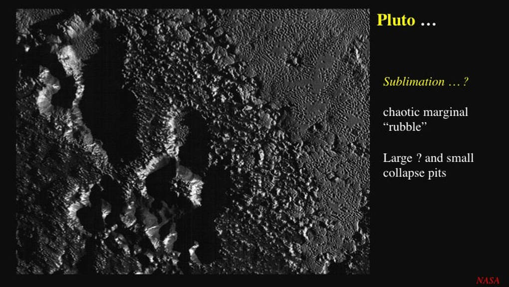
However, sublimation would not appear to account for these large pits formed in blocky water ice terrain. Apart from their size - an order of magnitude larger than the 1-2 km pits we’ve looked at so far - they have striations pointing downslope along their steep sides : clear signs of a component of collapse.
My take home message here is that nothing is cut and dried on Pluto with the current state of knowledge ... but it’s fun to speculate !
My take home message here is that nothing is cut and dried on Pluto with the current state of knowledge ... but it’s fun to speculate !
Proudly powered by Weebly

