|
MARS SCIENCE in 2020
|
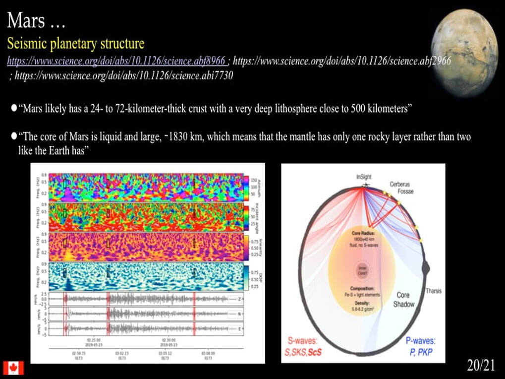
Over the past year I have given presentations on the current status of scientific inquiry regarding the Moon (https://www.simonhanmer52.ca/lunar-science-in-2019.html), Mercury (https://www.simonhanmer52.ca/mercury-2019.html), and Venus (https://www.simonhanmer52.ca/venus-magellan-images.html) as part of an ongoing update of where planetary scientists are at in terms of how they are currently thinking about the inner Solar System. Rather than try to cover all aspects of the detailed arguments involved, my intent has been to give a general sense of what questions planetary scientists are asking themselves these days and how they are going about answering them - or not! Here I want to turn to Mars.
You are all well aware of the excellent observations that have been made of the surface of Mars using multiple orbiting satellites that have enabled the construction of global maps such as this. You're probably also well aware of the principal geological features and their names too. You're also very familiar with the rovers that have been sent to the surface (e.g. Spirit, Opportunity and currently Curiosity).
This kind of remote field work is on-going and still has much to teach us about the planet's surface, especially through the efforts of the ESA and NASA's Hi-RISE program
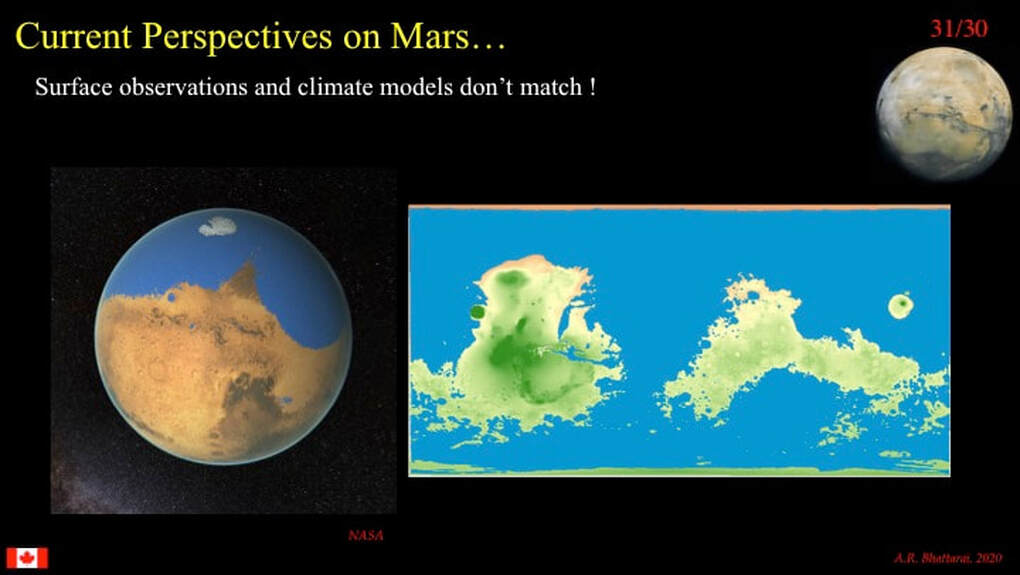
However, the pace of "break-throughs" on Mars is certainly slowing. Today, throughout 2020, and the preceding 5 years, much of the excitement and scientific frustration has focused on a fundamental conundrum : the apparent contradiction between the observation of surface features that appear to require flowing water to explain how they formed : i.e. dendritic (branching) river channel systems and lakes, and possibly a northern ocean, and the inability of climate modelling to predict such a climate at the appropriate time - early in martian history.
Although some highly creative folks have imagined what a northern, or even a global ocean on Mars might have looked like. Please … don’t take the global ocean too seriously !!!
Using impact crater statistics, planetary scientists estimate that the time frame for these water-related surface features is at the Noachian-Hesperian transition, which corresponds to around 3.8 Ga. So what's the problem? Carving branching river systems that are in equilibrium with the topography they flow over require sustained hydrology over 1000s to millions of years, as opposed to catastrophic floods (https://www.simonhanmer52.ca/voyage-to-mars.html). According to some, sustained hydrology requires sustained rainfall and runoff (water running over the surface in channels and flood plains) - and that requires a Warm & Wet climate. The problem is that at ~3.8 Ga, the Sun's energy output is thought by most to have been some 30% less than it is today, and Mars is a long way out from the Sun compared to the Earth or Venus. Hence the climate computer models tend to predict a Cold and Dry (icy) climate instead. Hence the paradox ... and scientists do NOT like paradoxes! So, much of the scientific effort regarding Mars today revolves around trying to sort this paradox out !
Before we look at how planetary scientists are trying to resolve the martian climate paradox, let's take a look at some very recent work that confirms the existence of river channel systems carved by flowing surface water on Mars. These digital elevation maps show you where the scientists were working : note the scale bars and the white dot. As we zoom in on the nested white boxes it will become very obvious why they chose this area.
This is Aram Dorsa (white box), a ridge that has anastomosing branches to the East that merge into a single meandering ridge to the West. Yes, I said "ridge, but how can a river channel system be described as a ridge? It's a very well known and well understood geological phenomenon.
Let's zoom in a bit and we'll see better. The top two images on the left are oblique views of the single ridge in the West of Aram Dorsa. The images are between 500m and 1km across and the ridge is clearly bounded on either side by steep scarps (you can only see the one facing us). The two lower images on the left are overhead views of parts of the branching ridges in the East of Aram Dorsa (note the scale bars here). The ridge patterns are identical to what we would expect from a braided river channel system, except that the topography is inverted : the channels are ridges. This occurs when the sand and gravel deposited in the channels by flowing water becomes indurated and ends up being more resistant to erosion that the muds that would have occupied the flood plain between the channels. Subsequent erosion (maybe by wind?) removes the mud deposits and leaves the sand and gravel as high-standing ridges.
Armed with this knowledge, planetary scientists can now reconstruct the extended river network plus all the smaller tributaries that you can see in this geological map. The big yellow impact crater that straddles the main channel in the West is a reminder of how we know that the channel system is Noachian / Hesperian (impact statistics).
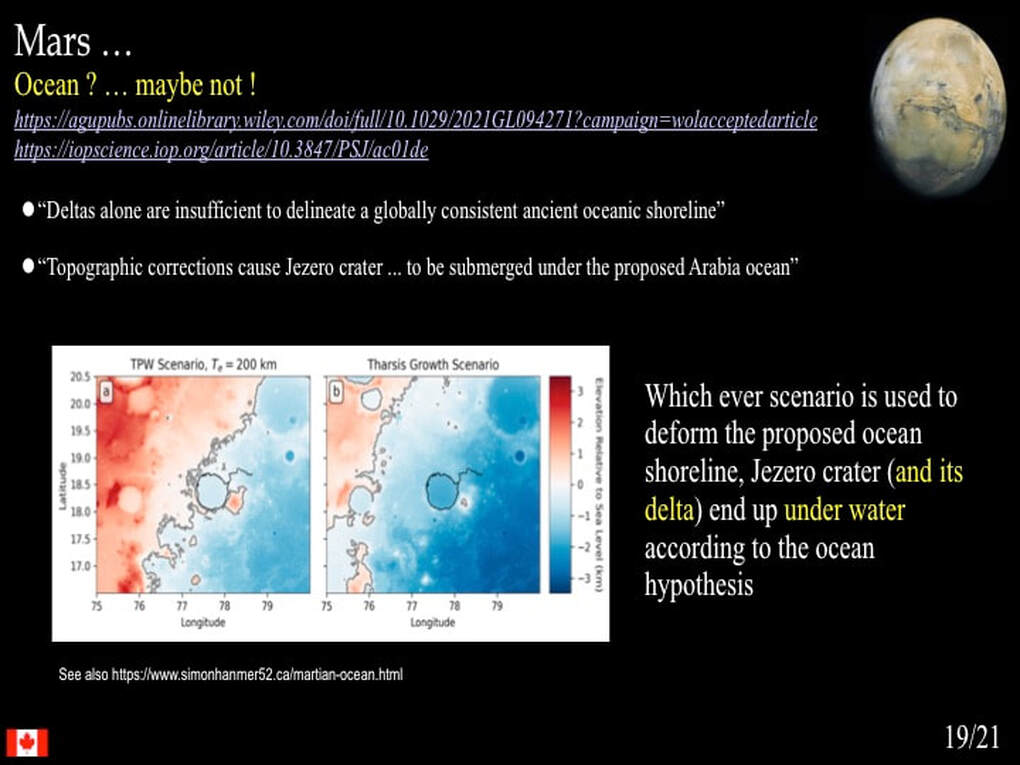
River channel networks aren't the only evidence for surface water on early Mars. Here's a very clever piece of detective work from almost a decade ago, but it's still very relevant to understanding how planetary scientists work today. They were looking at pairs of open and closed lakes that formed in impact craters on Mars. (Be aware : this image is an artist's impression, not the real McCoy). Open lakes are those where water flows both into and out of the lake. Closed lakes are those where water only flows into the lake. For water to flow out of an open lake the lake must've filled to at least the level of the out-going channel carved into the wall of the crater. This gives us an estimate of the minimum depth of water in that lake. For a closed lake in the pair, the lake could have filled to the level of the in-coming channel carved into the wall of the crater. This gives us a maximum estimate of the depth of water in that lake. While this is a neat model, it doesn't tell us when the hydrological cycle happened (although it would have been old ), nor how long it may have taken.
Other workers have applied interesting terrestrial analogues to sleuthing out the behaviour of ancient surface water. It turns out that we understand enough about the rates of side-ways (lateral) migration of the bends in rivers (meanders) to estimate how long a river must have been flowing. For example, we know the rates are very different for environments with vegetation and those without (deserts). It also turns out that you can model this rather well if the river in question is simple : i.e. a single channel (thread) without major tributaries. A recent example was the study of the channel that fed the delta fan in Jezero Crater on Mars. The model suggests that water would have flowed in the channel for about 20-40 years, but it could have happened in pulses over a ~400,000 year time window!
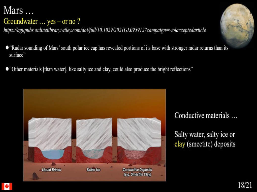
Another favoured line of research focuses on the chemical interaction between surface rocks and surface or near-surface waters (alteration). Using orbiting satellite data that detected different kinds of clays derived by the alteration of volcanic rocks, a recent paper suggested that at least some of the clays located in the walls of an impact crater require the presence of a long-lived, relatively deep lake. However, as you can imagine, there’s another school of thought that says the temperatures required for this alteration are too high for any early martian climate, so maybe the alteration was due to the heat of impact that formed the crater … and the debate goes on!
So we've just looked at a few surface features that are at least suggestive of long-lived surface water, but this is NOT where the main action is at the present time. Today, there's a lot of numerical modelling taking place where planetary scientists concoct imaginary atmospheres for early Mars to see whether an atmosphere of a different composition or a different pressure from that of today can help resolve the Warm & Wet vs Cold and Dry paradox. Here's a slide I redrew and simplified from a very recent paper that examined the potential instability of an early Mars climate if we add H2 gas (derived from volcanoes) with the standard CO2 +/- CH4 atmosphere that we usually assume for early Mars. What they were looking for is the thermal effect of H2 and CO2 colliding with each other and - for quantum physics reasons that I do not understand - absorbing and retaining more infrared radiation (heat) from the planetary surface than a simple CO2 atmosphere would. The model suggests that for relatively small changes (instabilities) in the rates at which CO and H2 are pumped into and drawn out of the planetary atmosphere (CO2 / H2 ratio : weathering vs volcanic activity), the martian climate could easily swing back and forth in temperature in response to relatively small orbital changes - despite the early faint Sun. It's a neat model, except that it requires improbably high atmospheric pressures for Mars (<3 bars).
Other planetary scientists have taken a different approach to creating model atmospheres for early Mars. It so happens that there are very specific relationships, well tested in the laboratory, between phases (solid-liquid-gas) and pressure and temperature. Hence, if ice, water and atmospheric water vapour are all present at a given atmospheric pressure, and their quantities are either known or can be assumed, the temperature can be determined. So a recent paper said : if you want a Warm & Wet early Mars, you have to have an ocean. So, let's assume that an ocean was present on Mars.
Could be big, could be small.
On Earth, where oceans are everywhere and permanent water ice currently occurs at both poles, the temperature distribution with latitude is pretty simple : cold at the poles and warm at the equator. However, for Mars the ocean (if there was one) was confined in the North (inset & blue panel), so the distribution of temperature is more complex. Here are some results of this modelling. We don't need to understand the details, but note the following : By varying the both the total atmospheric pressure and the partial contributions of CO2 and H2 they get different results for maximum and minimum temperatures (red and blue dots) as well as for the southern extent of the northern ice cap (red line), similar to other studies. Most importantly, the existence of a northern ocean allows for maximum temperatures in the southern hemisphere of early Mars to rise well above the freezing point of water - but does NOT disallow that the entire planet might be frozen solid! In short, liquid water if necessary, but not necessarily liquid water !
This is where things get even more intriguing. The same paper also looks at how the size of a potential martian ocean might affect the nature of water on early Mars : large ocean on the left vs small ocean on the right. The only thing I want you to notice here is that there are solid curves and dashed curves. The most important thing is that the solid curves are for rainfall. The numerical models can try to predict how much rain vs how much runoff (rivers and streams) occurred on early Mars. Now, notice how the curves for rainfall and runoff vary with the size of the northern ocean. Don't worry about the details (it's complicated), but you have to admit that this is pretty amazing stuff.
Well, if you're looking at rainfall on early Mars, then maybe you want to know about the size of the raindrops. On Earth we can look directly at fossilized examples of raindrop impacts, such as this ~350 million year old example from Nova Scotia. However, for Mars planetary scientists need to do some numerical modeling.
Why would they do this ? Well, according to one school of thought (though others disagree), because the bigger the raindrops and the faster they fall, the more they can erode the martian surface over millions of years - and just maybe we can observe that erosion from orbit – and, as these diagrams show, fog, drizzle and rain (storms) are a partial function of atmospheric pressure (left : fog at high pressure, rain storms at lower pressures) … and raindrop speed is a partial function of raindrop size and again of atmospheric pressure (faster at lower pressures). Hence the erosive power of raindrops is a reflection of the nature of the atmosphere, especially the atmospheric pressure.
Well, it's pretty obvious that river channels are observational evidence of water running over the planetary surface (runoff), but how would we recognise the diffuse, distributed effects of erosion by the impact of large, fast-falling raindrops from orbit? It turns out that the oldest impact craters, those that formed before the river channels formed, were already "degraded" by the time the channels formed.
What does "degraded" mean ? It means that the sharp edges of the tops and bottoms of the impact crater walls were rounded off by a very diffuse erosional process : the impact of raindrops. Since these "degraded" craters are then cut by localised erosional river channels, it has been proposed that the martian atmosphere must have evolved from an initial foggy climate (high pressure), via drizzle and rain storms (lower pressure), to a runoff regime at even lower atmospheric pressures.
NB : mass wasting and micrometeorite gardening are also diffusive erosional agents, but they are considered second order after raindrops by some schools of thought
This transition is illustrated in the upper image and represents what is predicted for a Warm & Wet early Mars climate, with time running from left to right.
But hang on just a minute here, this is science ; and as you have now come to expect, there is always another way of looking at the same evidence : there’s always another school of thought. Take a look at the lower diagram that illustrates the possible evolution of temperature through time (upper panel) and channel erosion by runoff through time (lower panel) assuming a Cold & Dry early Mars. This school of thought says : well, what happens if the early Mars climate is Cold & Dry, but catastrophic events occur that "punctuate" that environment and temporarily increase the surface temperature above the freezing point of water such that rivers can flow, even if they are relatively short-lived ?
But hang on just a minute here, this is science ; and as you have now come to expect, there is always another way of looking at the same evidence : there’s always another school of thought. Take a look at the lower diagram that illustrates the possible evolution of temperature through time (upper panel) and channel erosion by runoff through time (lower panel) assuming a Cold & Dry early Mars. This school of thought says : well, what happens if the early Mars climate is Cold & Dry, but catastrophic events occur that "punctuate" that environment and temporarily increase the surface temperature above the freezing point of water such that rivers can flow, even if they are relatively short-lived ?
In addition, there is another school of thought that suggests that major asteroid impacts could transform their kinetic energy into heat and melt frozen CO2 to drive "punctuated" global warming on a Cold & Dry early Mars. A recent study took a look at this option using numerical modelling. They calculated temperature, precipitation and cloud cover for various sized impactors hitting an early Mars with various atmospheric pressures.
Again, the details are really not important here. Here’s one of their calculated diagrams for a 50km diameter asteroid impacting a very thin atmosphere (0.15 bar).
What's important is that you see how, by varying a single variable (here the assumed atmospheric pressure), the modelled temperature, precipitation and cloud cover can change dramatically. Who's to know which modelled result is more probable ?
Most importantly, note the very short time frames for the calculated warm periods.
Well, you might think that we've reached the penthouse of martian climate modelling here, but I would suggest that maybe it's only the 13th floor! None of the foregoing very recent modelling efforts have resolved the paradox we started out with : surface observations and climate models still do not match. No-one has convincingly modelled long, extended periods of sustained Warm & Wet climate for early Mars. So yet other planetary scientists have sought to explain erosional river channels in a Cold & Dry environment, inspired by what we can observe in the terrestrial tundra : sub-glacial river channels.
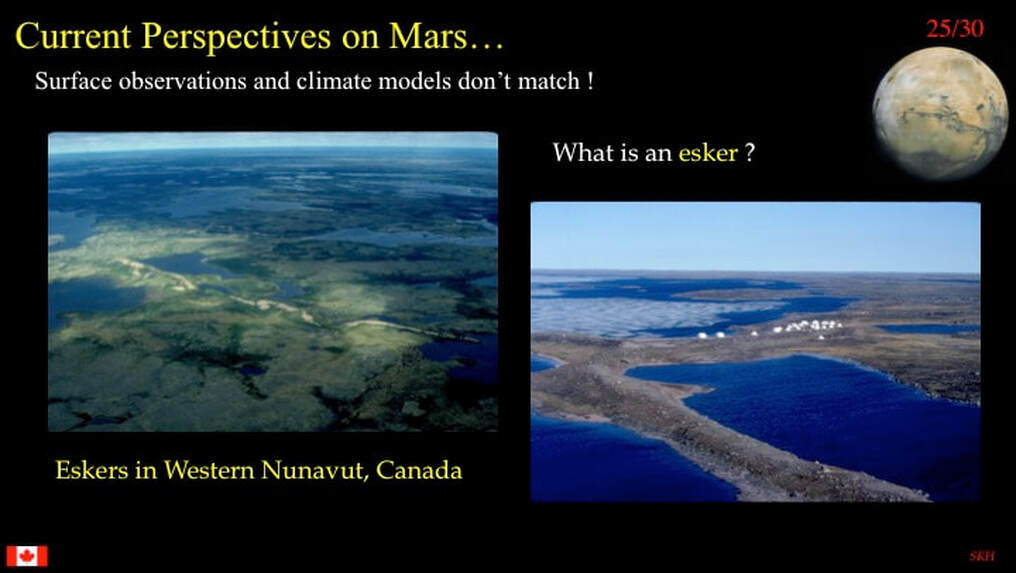
The Canadian tundra is criss-crossed by eskers. What is an esker? At its simplest, an esker is a tunnel carved under the polar ice cap (or a glacier) by flowing water (often under pressure - so it could flow uphill !) carrying huge amounts of sand, gravel, pebbles and boulders. This sediment charge is dumped in the ice tunnel as the flowing water current eventually wanes - and when the ice retreats it leaves meandering, sometimes dendritic (branching), ridges all across the tundra. These are two examples I photographed from the air in NW Nunavut.
The Canadian tundra is criss-crossed by eskers. What is an esker? At its simplest, an esker is a tunnel carved under the polar ice cap (or a glacier) by flowing water (often under pressure - so it could flow uphill !) carrying huge amounts of sand, gravel, pebbles and boulders. This sediment charge is dumped in the ice tunnel as the flowing water current eventually wanes - and when the ice retreats it leaves meandering, sometimes dendritic (branching), ridges all across the tundra. These are two examples I photographed from the air in NW Nunavut.
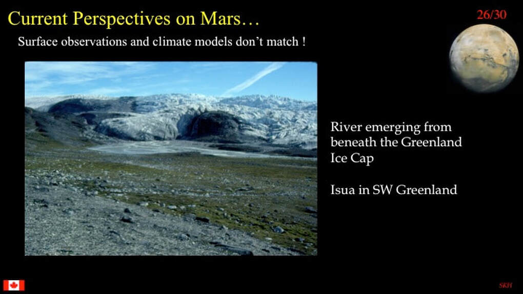
Here's an example I photographed of a sub-glacial river exiting from beneath the Greenland ice cap. You can see the exiting water as well as the exposed esker ridge of gravel and whatever.
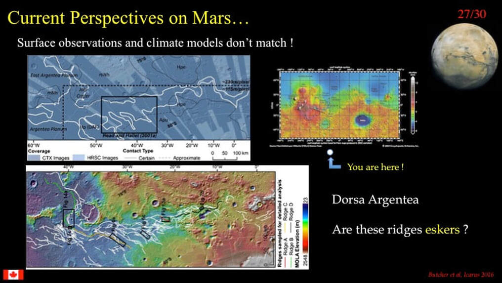
Between Northern Canada, Scandinavia and Siberia and the rest of arctic Russia we have lots of statistical observations of what eskers do and do not look like. So it's no surprise that planetary scientists have looked for eskers on early Mars and think that they have found them : lots of them! Here's an example from near the martian south pole (white dot) of a system of ~3.5 Ga (early Hesperian) ridges that planetary scientists think really do look like eskers, and therefore provide first order evidence for sub-glacial channel flow of liquid water.
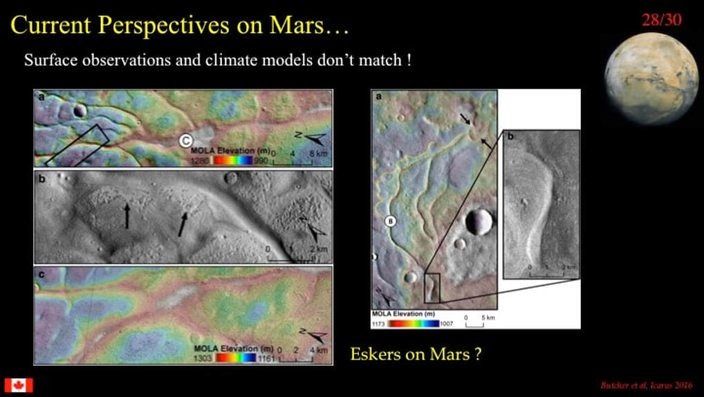
Here's what these ridges look like - and yes, they can locally run uphill downstream! Take it from me (and from the scientists), they really do make a good case for eskers and sub-glacial flow on Mars
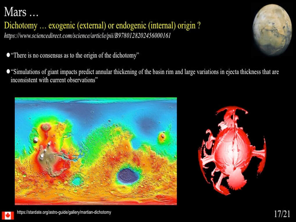
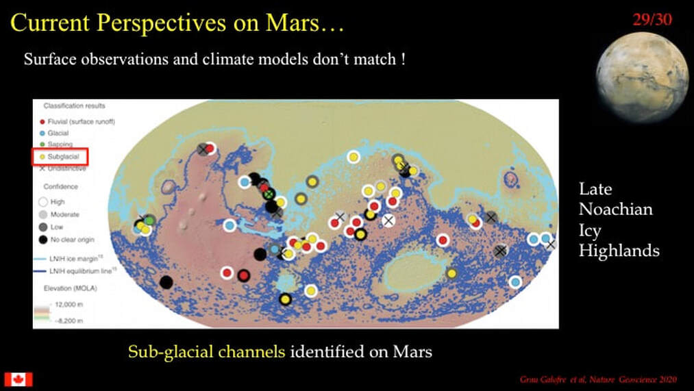
This map shows where yet another group of planetary scientists also found observational evidence of sub-glacial channels (yellow dots : red box) distributed in the vicinity of the dichotomy boundary between the Southern Highlands and the Northern Plains, i.e. at the southern edge of a potential northern early Mars ice cap.
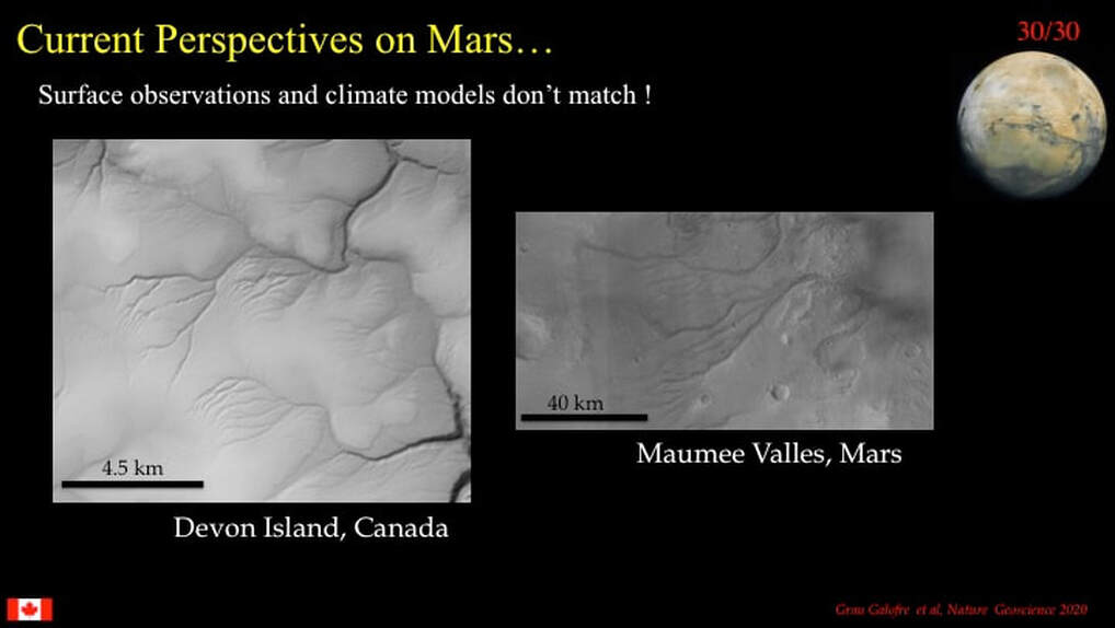
However, this group was not looking at eskers. They were looking directly at sub-glacial erosional channels and compared them to terrestrial examples from Devon Island in Northern Canada. You have to admit ; the resemblance is striking. They may well have a point!
So, what's my take-home message here ? Planetary science with respect to the inner Solar System is currently in a state of flux : certainly at NASA, if not elsewhere. There’s a kind of « mission creep » occurring. Rover missions to Mars were essentially sent to ground-truth high resolution orbital observations of the bedrock and surficial geology, all in the context of the mantras of « Follow the Water » and « Where there’s water, there’s life! ». However, the frustration that drives the next step in a scientist’s curiosity has shifted in very recent years to finding ways to resolve the early martian climate paradox, and that’s all well and good.
We saw the same « mission creep » from surface to atmosphere with respect to Venus during my last presentation - and just a few weeks ago you all saw the headlines suggesting that the next steps in Venusian scicnce should switch, almost over-night, to a search for microscopic life forms floating in Venus’ uppermost clouds. Chasing the paradox of the early martian climate can still fit within a balanced, holistic (global) research programme for the red planet. However, chasing potential live bugs in the context of Venus at the expense of a mature, well designed planetary survey sounds to me like finance-driven ambulance chasing.
But then … that’s just my opinion, and what do I know?
Proudly powered by Weebly

