|
Mercury
|
As many of you may know, I follow the scientific literature on planetary geology as both a professional geologist (albeit retired and recycled) and as an amateur astronomer. Much of it tends to be more of the same with young scientists simply reiterating what the scientific community already thinks it knows, but in a slightly different place or with a slightly different perspective. However, every now and again, a paper pops up that sets me back on my heels and proposes something really different, something that makes me say "Goodness, I had no idea !", or less repeatable words to the same effect. One such paper came to light recently concerning the planet Mercury ... “Mercury’s Hidden Past: Revealing a Volatile-dominated Layer through Glacier-like Features and Chaotic Terrains", by Rodriguez et al., published in The Planetary Science Journal last November.
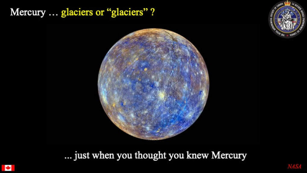
Now just hang on a minute here. The daytime temperature on Mercury can reach 400*C at the equator ... Why would anyone think there are "glaciers" on this planet ? Well, it depends on what we mean by "glaciers", which explains the quotation marks in the title of this slide. Geologically speaking, the term "glacier" can apply to a sheet of something solid that flows on the surface of a planet. Most folks, when they think of glaciers, think of "ice". However, other stuff can flow like a glacier too ...
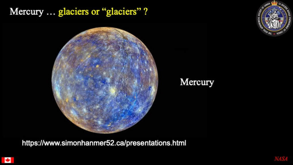
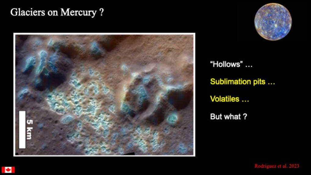
One of the big surprises from the MESSENGER mission that entered orbit around Mercury in 2011 was the presence of blue-ish patches spatially associated with small pits that generally occur within impact craters. Referred to as "Hollows" they are interpreted as pits that formed when "volatiles" stored beneath the planetary surface sublimated, leaving underground voids into which the surface materials collapsed. I presented a talk that touched on this to Ottawa RASC in 2019, but you 'll have to go to my personal website to find it (simonhanmer52.ca/presentations). But what volatiles are we talking about here and why did they sublimate ? ... and what has this got to do with "glaciers on Mercury" ? We'll get to that shortly.
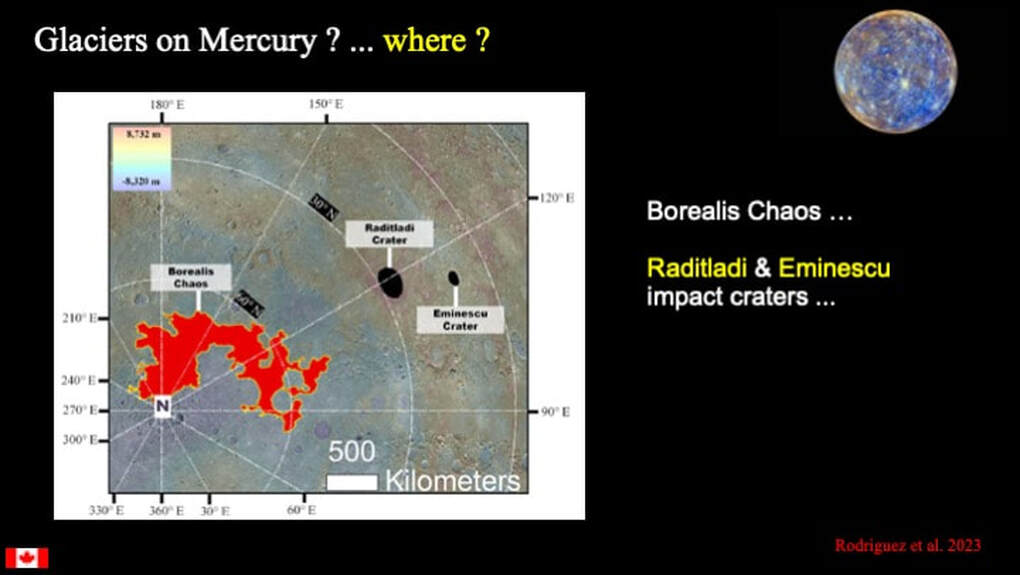
The authors of this paper on "glaciers" investigated two types of terrain near the north pole on Mercury. The first was located in a couple of impact craters (Raditladi and Eminescu), shown here in black. The second is a vast irregular patch (red) of chaotic terrain called (Borealis Chaos).
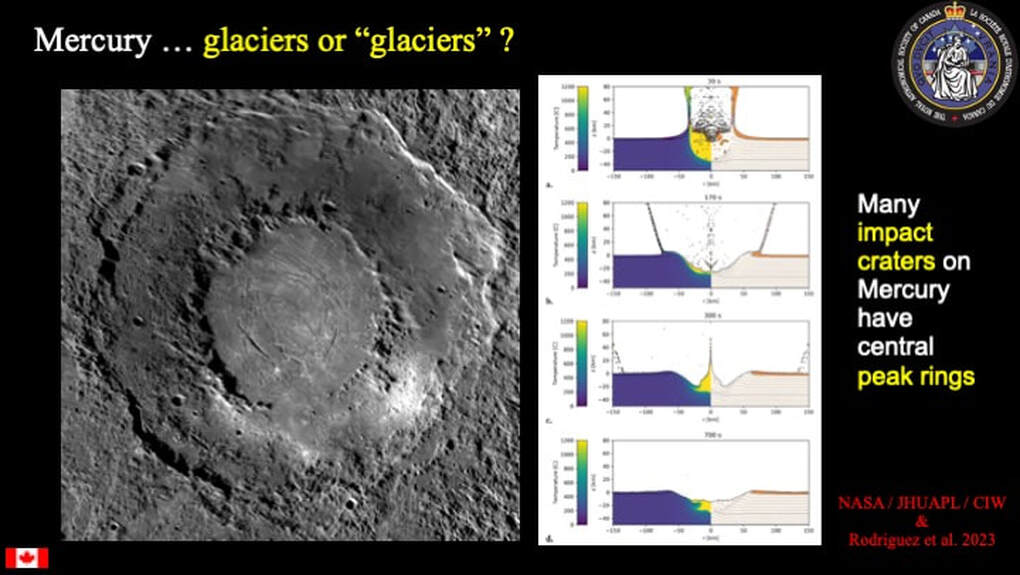
Back in 2008 (just after a MESSENGER fly-by of Mercury) I presented a talk to the Ottawa RASC (but you 'll have to go to my personal website to find that one too) where I pointed out that one of the characteristic features of impact craters on Mercury is that so many of them have central peak rings, as opposed to simple central peaks, They occur on the Moon too, but they are more common on Mercury. It's all down to the velocity of the impactor which is a partial function of the gravity of the body being impacted, which is greater on Mercury than on the Moon because it has an anomalously huge FeNi core (see my 2003 presentation to the Ottawa RASC ... and yes, you'll have to go to my website to find that one as well).
Why am I telling you all this ?
Why am I telling you all this ?
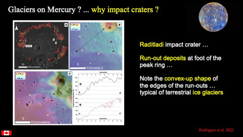
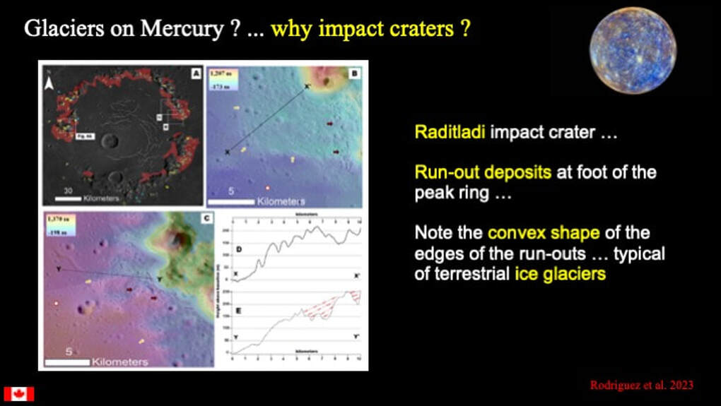
To understand why glaciers on Mercury might be linked to impact craters let's take a closer look at Raditladi Crater. At top left is the peak ring of Raditladi Crater. Note the lobate brown patches at the foot of the peak ring. These are referred to as flows or "run-outs". Note also the scale bar (30 km), and the white boxes B & C. At top right and bottom left are detailed images of the white boxes B & C. Note the scale bars (5 km). In both images, parts of the peak ring are seen at top right and the flat floor of the impact crater is to lower left and the edges of the run-outs are indicated by yellow arrows. There are also red arrows that point to examples of groups of sublimation pits ... or Hollows. Notice how they are confined to the surface of the run-outs. Finally, note the black lines (X-X' and Y-Y') drawn across the two run-out examples. The diagram at lower right shows the topographical profiles along these two lines. Notice that both of the profiles are convex-upwards and that they abruptly drop down to the crater floor as they terminate (left). The authors of the paper suggest that these run-outs, some 10 km in horizontal length by 200-250 m in maximum vertical height (thickness), show the same topographical profiles that one would expect to see at the edge of a glacier of flowing ice.
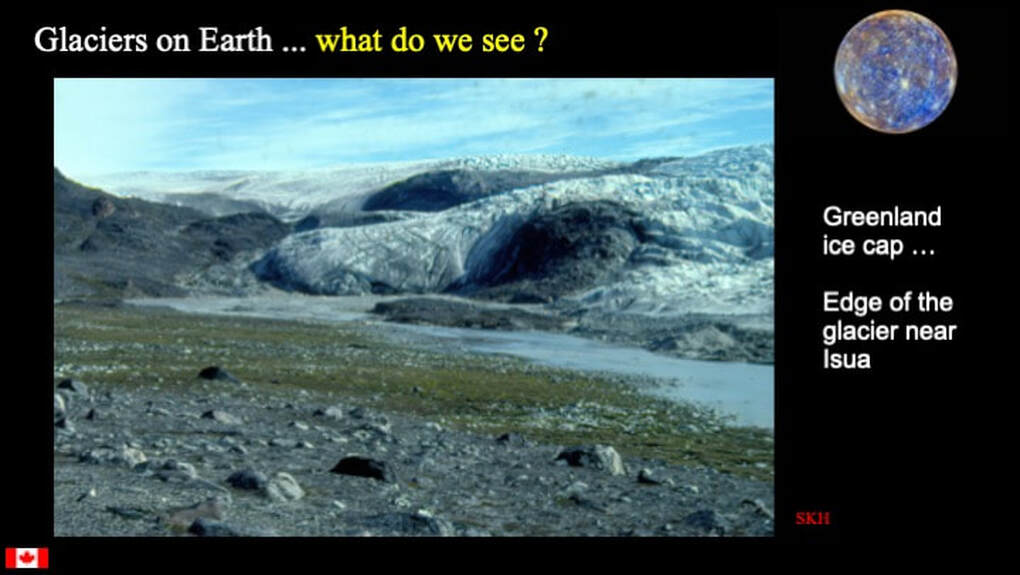
Well, I have seen the edge of the Greenland Ice Cap, and indeed they are right. Look at the shape of the edge of this ice glacier : convex up with an abruptly steep terminal slope !
They ... the authors ... suggest that these run-outs are made of some kind of volatile-rich material (hence all the sublimation pits) that flowed from the tops of the peak ring down to the floor of the impact crater to form the lobate deposits that look very much like glaciers of ice on Earth.
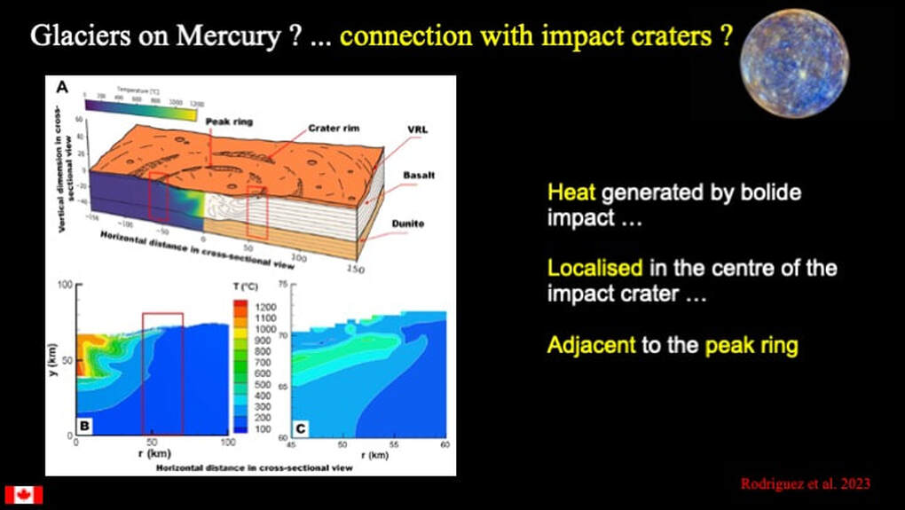
So ... what's the causal connection with impact craters ? Well, when a bolide (e.g. an asteroid or comet) hits a planetary surface, its kinetic energy (the energy of motion) is converted to the energy of heat, and that heat is localised in the centre of the impact crater ... right under the peak ring. So the idea is this : Before impact there was a volatile-rich layer of something buried just below the planetary surface (VRL). When the surface was impacted, heat was generated in the central part of the crater, as the peak ring rose up, thereby uplifting warmed-up (and softened) volatile-rich material and providing a slope for it to run down.
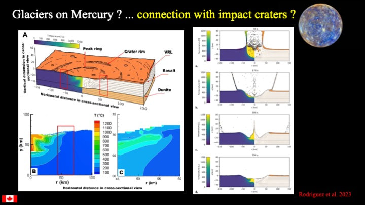
Here is the cross-section we just looked at plus the sequence of events during the formation of an impact crater (right). Notice that the scales are all in km so the height of the peak ring is not very pronounced in these images, but it's high enough to gives us the slope required for something warm, soft and volatile-rich to flow down.
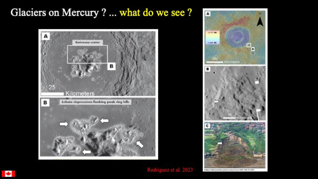
Now we have to ask " is Raditladi Crater just a one-off ; s it just weird ; or are we looking at something systematic here ? That's why the authors also looked at Eminescu Crater, which has a somewhat smaller peak ring. Well, it certainly does share the same features as Raditladi Crater, so we seem to have a pattern developing here. Interestingly, when we look at the topography of the main rim of the impact crater (top right - white box B), we do not see the same features. We see simple landslides with concave-upward topographical profiles, and no sublimation pits (middle right) ... just like standard terrestrial landslides (bottom right).
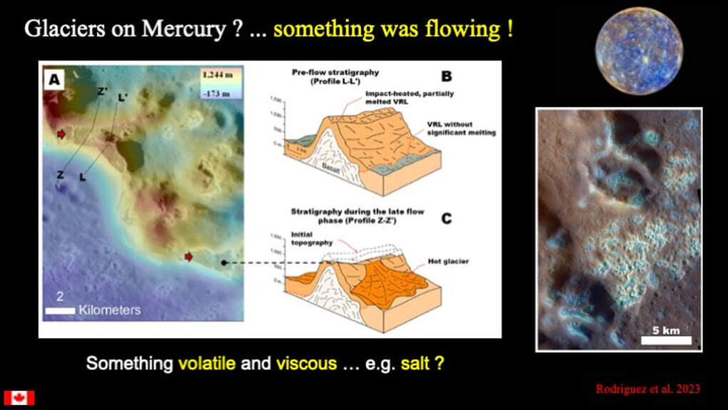
So... something warm and soft with lots of volatiles was flowing from the upper parts of peak ring topography down to the foot of the slope and out onto the crater floor. But what ? It may look like an ice glacier ... but not at >400*C !! Planetary scientists have kicked around a number of candidates to explain the blue-ish sublimation pits of Hollows discovered over a decade ago, including S, C (graphite), Cl, Na and K. However, none of these is viscous enough under the surface conditions of Mercury (too runny). Alternatively, salt (NaCl) could fit the bill and it is volatile on Mercury !
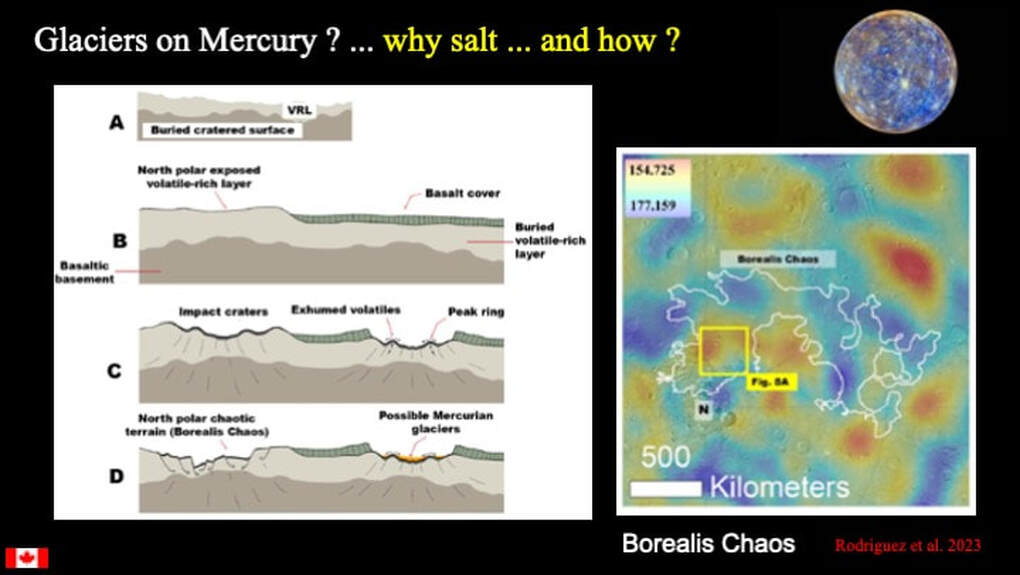
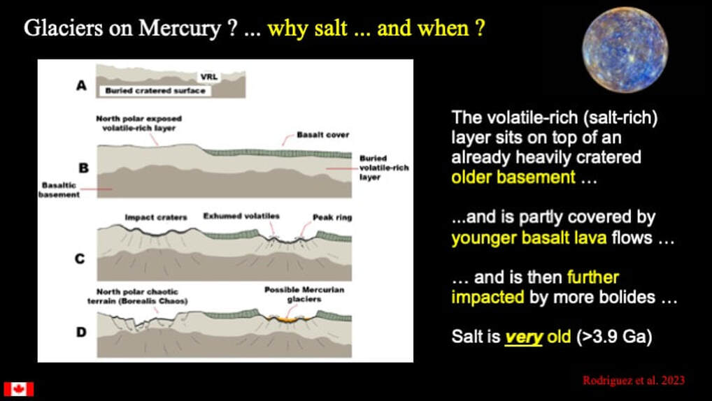
OK ... Salt ! But what is salt doing on Mercury and how widespread is it ? On the left is the authors' cartoon of the geological setting of salt on Mercury. #A shows an ancient buried rocky basement that is covered by a younger layer rich in salt ... we'll worry about where the salt came from in just a second. How do we know there's an ancient buried rock basement? Because the gravity map of Borealis Chaos (right : note the scale bar - 500 km) shows us localised mass anomalies (red/yellow) that are interpreted to represent ancient - now buried - impact craters that are older than the salt layer.. #B shows part of the salt-rich layer that was buried under even younger basalt lava flows, but not everywhere. #C shows that when more bolides impacted Mercury, the impact craters in the younger basalt lava areas remained discrete with peak rings, while in areas with no basalt re-enforcement, the impact craters tended to collapse and coalesce into one another in a chaotic jumble when the volatile salt volatilised or sublimated and created buried cavities that collapsed on themselves !! In #D salt glaciers formed in discrete impact craters in the younger basalt lava fields, but chaotic terrain formed where the protective younger basalt lavas were absent, forming vast areas of surface collapse such as Borealis Chaos.
OK ... so if Borealis Chaos formed because the salt layer exposed by bolide impacts volatilised into outer space, why can we see salt glaciers in impact craters ? Quite simply because the salt in the glaciers was mixed with rock and when the salt sublimated, we are left with what is in effect a rock glacier ! (a glacier fossilised in rock).
Do you see where this is going ? If something as vast as the Borealis Chaos is underlain by a salt-rich layer, just how widespread might such a layer be ? If it is planet-wide, just how could that happen on a dry planet like Mercury ?
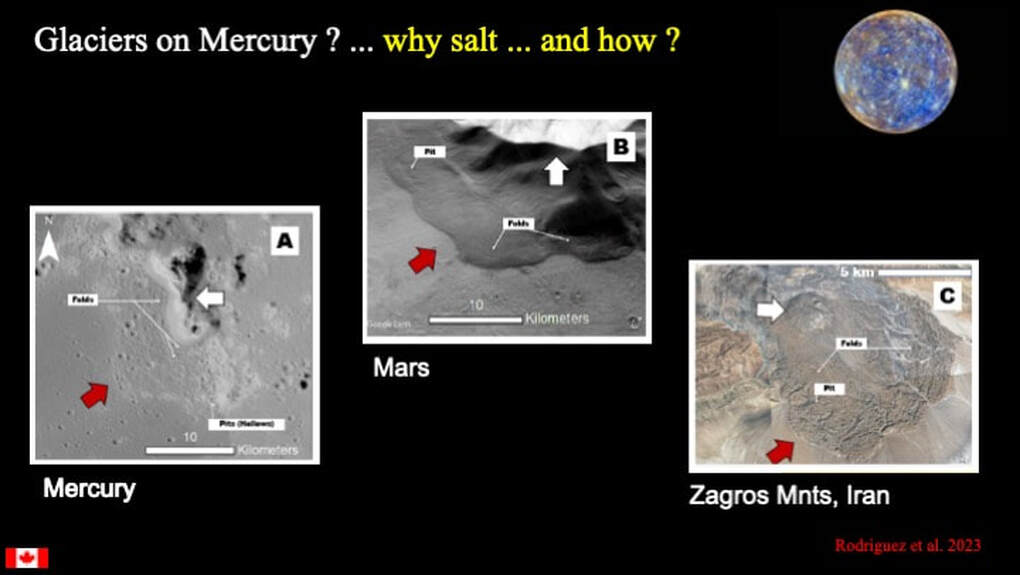
So ...this looks like a great story for Mercury, but how do these "glaciers" compare with glaciers known from elsewhere in the Solar System ? Here's a comparison by the authors between salt glaciers on Mercury, an ice glacier from Mars (now a rock glacier), and a salt glacier from the Zagros Mountains in Iran on Earth. I think the first two are easy to compare. Both show something viscous that has flowed down a slope, with folds at the bottom of the slope and sublimation pits. The Iranian example is more difficult to see ...
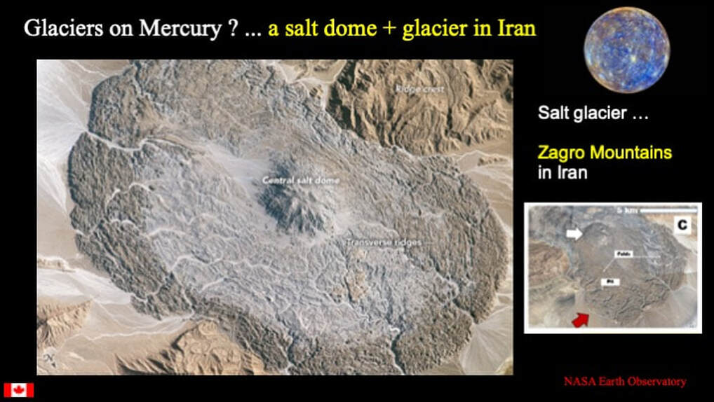
So here's a NASA image from the same area in Iran where you can better see the central salt dome , and the salt that flowed away from the topographical peak of the salt dome and piled up in ridges (folds), and the steep convex-upward slope that ends abruptly at the edges of what is considered a classical salt glacier.
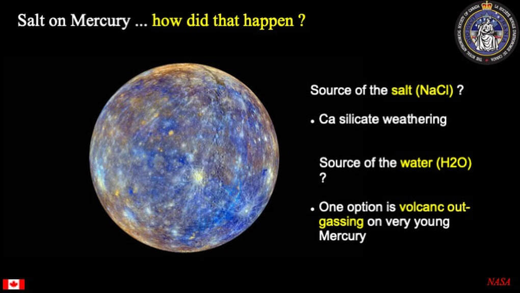
Now, how - on a dry planet like Mercury - could a regional-scale (potentially global) salt-rich layer possibly form ? On Earth we would invoke the evaporation of vast, shallow seas or lakes, but how would you do that on Mercury ? What would be the source of the salt, and what would be the source of the water to form shallow seas and lakes ? The authors of the paper examined this question pretty thoroughly. The sodium in the salt (NaCl) could be derived by the break-down (weathering) of Na-bearing minerals that make up the basaltic crust of Mercury : feldspars and pyroxenes ... the mineral components of basalt lavas.
Yes, the slide says Ca silicates ... but Na occurs in Ca silicates !
However, it's their interpretation of the source of the water that came as the great surprise for me. One obvious potential source would be the out-gassing of a primeval magma ocean as it cooled and crystallised. But given the existence of an ancient heavily cratered solid rocky basement beneath the salt-rich layer, that's not possible. So the next obvious option is that the water came from the out-gassing of the mantle of Mercury via volcanic activity and the massive volcanic out-pouring of basaltic lavas that we see at the surface.
Now comes the best part ...
The authors of the paper suggest that this out-gassing gave rise to a water-rich temporary atmosphere of hot steam that "collapsed" as it cooled. "Collapsed" in this context means that, as the temperature dropped, the atmosphere condensed from a steam bath to surface water that was sufficiently voluminous to form vast shallow seas and perhaps lakes. Now THAT set me back on my heels ... in the context of a now dry planet like Mercury ! That's what I call a real change in perspective !!!
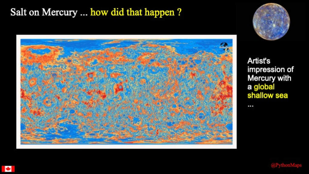
So, what do you imagine that an early Mercury covered by shallow seas might have looked like Well, how about this artist's impression of just that. I have to admit that I'm a bit unclear on the geography !!!
So there you have the story of salt glaciers on Mercury ... but when did this evaporating salty sea occur ? The salt-rich layer sits on an older, already heavily bombarded basement - probably of made of basalt lava It is partly covered by further outpourings of younger basalt lavas, and then is well and truly beaten up by more heavy impact bombardment. When did all this heavy impact bombardment take place in the history of the Solar System ? At the very latest prior to 3.9 billion years ago ... and maybe well before 4.0 billion ! So this story is old - very old - and relates to the early days of the Solar System itself.
All this to say that these are exciting times to be following planetary geology ! Just when you think you have a good grasp of what's going on ... you can get quite the surprise !!!
Proudly powered by Weebly
